
The new 2021 Rand McNally road atlas is available. Here is what they have for the Chicago region on the Illinois page (available on the preview):
As my family or I have owned a version of this atlas for many years, I have spent much time viewing this page. I can recall when new roads were added (like I-355). Here is what strikes me upon seeing the Chicago area in the 2021 version (not the more zoomed in regional map which can offer more detail):
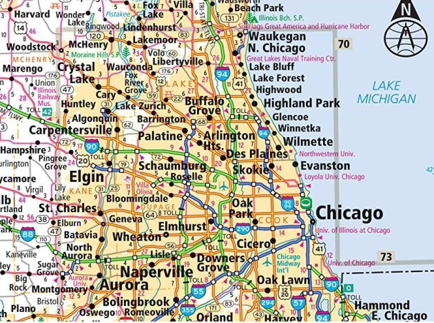
- The map cannot mention the names of all of the suburbs; there is not enough room. The ones listed appear to be the suburbs larger in population mixed in with some of the communities between those.
- This particular map does not clearly mark the boundaries of Chicago. You can roughly see where Chicago’s edges are due to the positions of other communities. Yet, the edges of the suburbs are marked – see the orange areas versus white areas – though some of the non-suburban areas within the developed areas are oddly marked.
- What non-municipal features are noted is interesting. Midway Airport has a label, O’Hare does not. Four universities along the lakefront are marked but DePaul and many others in Chicago and the region are not. There are some natural features and parks visible but not many (for example, it would be very difficult to know from this map all the forest preserves present in the counties in the region).
- The lake is present and useful for the map because some of the labels can go off into the water rather than compete for space over land.
- You might be able to get a sense that the road system in the Chicago area is both easy to understand and has a complicated history. The roads are fairly straight and the main highways largely radiate out of Chicago (I-94 north, I-90 northwest, I-88 west, I-55 southwest, I-57 south). But, then there are some shorter highways, two ring highways (I-294 and I-355) but not a third one to service outer development, and the toll/non-toll options blend together.
Making this map likely required a lot of decisions as to what to include and what would help make the map readable.
