A significant minority of Chicago area residents can’t find affordable housing

A new report suggests many Chicago area residents – poor and wealthier – have difficulty finding affording housing:

To identify “distressed homeowners and renters,” researchers used a housing rule of thumb that requires affordable housing to cost no more than 30 percent of a household’s gross income. In Chicago, 48 percent of people said they were devoting more than 30 percent of their income to rent or a mortgage. In the suburbs, 40 percent were stretching beyond the manageable 30 percent limit.

According to the research, 11 percent of households in Chicago had cut back on healthy food, and 12 percent had made cuts in health care to afford housing. Another 11 percent moved to less safe areas.

While the problem of finding affordable housing is most acute among people ages 18 to 34, African-Americans and households with incomes under $40,000, 49 percent of those in households with incomes over $75,000 said “it’s challenging to find affordable housing in my area.” Sixty-six percent of people with incomes under $40,000 noted the challenge…

In the Chicago area, 87 percent of adults said having stable housing that is affordable is a very important part of having a secure middle-class lifestyle, while 67 percent said it’s harder to afford stable housing than for previous generations.

Housing is crucial for many other areas in life as it influences daily well-being (do you feel safe?), schools that kids go to, amenities (local municipalities, recreation, retail, etc.) available nearby, what kind of neighbors you will interact with, commuting times, and more. So, if you don’t have the resources to live in a nicer community or have to stretch yourself, that will have consequences.

Is it time to reconsider the 30% rule? Of course, if you spend more than 30% on housing then you have to cut back elsewhere. But, given the housing bubble of the last decade and perhaps a new normal of higher rents and less new cheaper housing, perhaps Americans may have to devote more to housing in the future?

Mr. Selfridge got his start in Chicago’s department stores

Henry Gordon Selfridge hit it big in London (and on PBS) but got his start in Chicago’s burgeoning department store scene:

“Within a short time after he entered the employ of the Field store he met the first Marshall Field and made a favorable impression by asking for a job as manager of his department,” the Tribune recalled upon Selfridge’s death in 1947. “He won the job and from then on his rise was rapid.”He proved to have a knack for advertising, then a rare business skill. He was the first to promote holiday sales with the reminder: “Only ___ shopping days until Christmas.” Some credit Selfridge with the department store’s celebrated motto: “The customer is always right.”

In 1890, he became a partner in Marshall Field’s and married Rose Buckingham, a member of a prominent Chicago family. One of Rose’s bridesmaids, Kate Buckingham, donated Buckingham Fountain in Grant Park. An entrepreneur in her own right, Rose bought property on Harper Avenue between 57th and 59th streets, where she built and sold 42 homes. She also was an accomplished horticulturist. The Tribune reported she had a collection of 2,000 orchids…

The girls got a shot at marrying into the nobility because their father transferred the family’s fortunes to England, almost on a whim. In 1904, Harry Selfridge sold his interest in Marshall Field’s for $1.5 million and bought another Chicago department store, a few blocks south on State Street…

Yes, there was a Selfridge’s in Chicago before there was one in London. But not for long. Having bought it in May, he sold it in June — and the new owners renamed it Carson Pirie Scott & Co. Selfridge then went for a visit to London, where he discovered two differences between doing business there and in Chicago.

Chicago contributed much to the development of department stores which helped transform American retailing. Perhaps London makes for a more attractive place to tell the department store story but Chicago would be a pretty interesting setting in itself with department stores around the turn of the century. Why continue the Dick Wolf Chicago Fire/Med/PD/Justice system when you could go back into an even quicker changing era. Additionally, it would be interesting to see someone tie together several strands of American stores: from general stores and department stores to the big box companies and ubiquitous chain pharmacies of today.

First project mapping cities of the last 6,000 years

Since their rise thousands of years ago, cities have transformed social life and societies. Here they are in map form:

A new paper published in Scientific Data takes a stab at mapping the information Chandler and Modelski gathered. Yale University researcher Meredith Reba and her colleagues digitized, transcribed, and geocoded over 6,000 years of urban data. She and her colleagues write in their paper about the significance of their effort:

Whether it is for timely response to catastrophes, the delivery of disaster relief, assessing human impacts on the environment, or estimating populations vulnerable to hazards, it is essential to know where people and cities are geographically distributed. Additionally, the ability to geolocate the size and location of human populations over time helps us understand the evolving characteristics of the human species, especially human interactions with the environment.

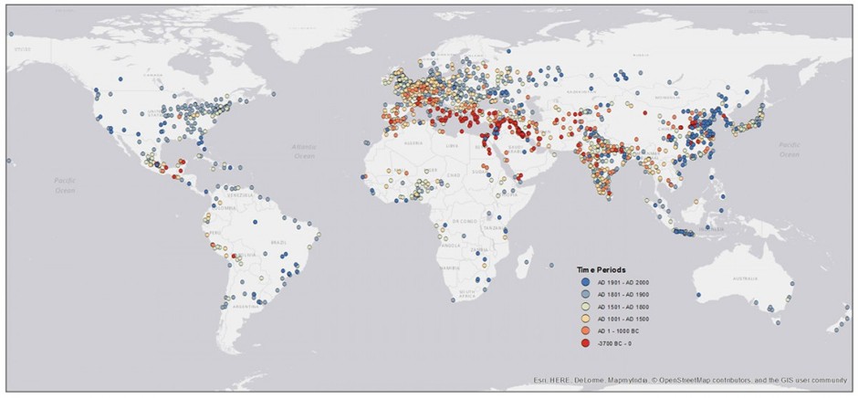
Their map, pictured below, plots the first recorded populations for all urban settlements between 3700 B.C. and 2000 A.D. The earliest records available are in the warmest colors, and are clustered around Ancient Mesopotamia. The latest ones on record are in blue. (To be clear, the map shows when the populations of cities started being documented, not when and where these cities were actually “born.”):

This has been oft-studied – the cradles of civilization and all – but it is still helpful to see the spread from these areas to other centers. It is remarkable how many newer cities there are on this map, particularly in the Americas and east Asia. In other words, some parts of the world have had cities for millennia longer than other areas. At the same time, the recent rise of megacities is a relatively recent phenomenon since the Industrial Revolution and many of these cities are in places where cities are relatively new.

A declining number of American gas stations

The number of gas stations in the United States has dropped in recent years:

But gas stations have been in decline for decades. Between 1994 and 2013, the number of retail fueling sites in the U.S. fell from 202,800 to 152,995—a 25 percent decline. In 2015, the number had slipped to about 150,000. (See page 31 of this report from the National Association of Convenience Stores.) And with several powerful megatrends arrayed against them, there are signs that their numbers could shrink significantly in coming years.

Let’s start with gentrification. (And this is the good news.) In many urban areas, gas station owners are finding it simply doesn’t make economic sense to keep selling gasoline—for reasons having nothing to do with demand for their product. As America’s great cities revitalize and attract more wealth, land is becoming exceedingly expensive. In many cities, and especially in New York, a gas station falls far down on the list of the best things to do with a piece of land. Owners realize they can run their businesses at modest profits for years to come or sell out to developers for giant premiums. In Manhattan, where the best use for a gas station is a site for condominium or office development, the number of gas stations fell by a third between 2004 and 2014—to just 39. As the New York Times reports, “Today there is not a single operating gas station left on the city’s East Side from the southern tip of the island to 23rd St.” The conversion of gas stations into apartments and offices is also starting to happen in other land-constrained cities such as Boston; Washington; and especially San Francisco, where at least two-dozen gas stations have made way for other developments over the past six years.

Several other trends are afoot that will lessen the underlying demand for gas stations’ core product. Gasoline, which was pretty much the only transportation fuel for vehicles until very recently, is slowly being displaced by a couple of sources, neither of which relies on gas stations to deliver them. First, there’s natural gas. Cheap and abundant thanks to fracking, compressed natural gas and liquefied natural gas are emerging as options—not so much for consumers and individual cars but for fleets. One of my favorite sites, NGT News, documents how operators of huge delivery fleets such as UPS or giant armadas of garbage trucks such as Waste Management are systematically switching their fleets to run on natural gas–based fuels instead of gasoline…

The other force is electricity, of course. The penetration of electric cars in America’s fleet is still very low. But every month, several thousand new cars hit the roads—Teslas, mostly—that don’t use any gasoline at all and will never, ever, ever stop at gas stations (unless their drivers need to make a pit stop for a Fresca or beef jerky). Sales of all-electric cars are running at about 6,500 month, according to Hybrid Cars. But there are signs of greater electrification. About 6,000 plug-in hybrids, like the one I drive, are sold every month. And there are many, many more to come. Tesla has already taken reservations for more than 370,000 Model 3s.

If this is indeed a declining industry, it will be interesting to see who is able to stay afloat the longest.

Two additional thoughts:

  1. While it is widely accepted that Americans like driving, it is less discussed how many other industries and firms depend on this. Gas stations exist because people regularly need to fill their vehicles and then a set of practices arises around stopping for refreshments and the restroom (they become convenience stores), getting a car wash, being able to take road trips, etc. What happens to drive-thrus if self-driving cars take over? What about big box stores and shopping malls? Less driving means not just fewer cars but a changed way of life.
  2. The paragraph above on gentrification hints at this but all that land formerly occupied by gas stations represents a significant opportunity. Imagine Shell goes out of the American gas station business. Who takes over all that prime real estate? The market might be limited for such land (just how many fast food chains can there be) even though it is often located at busy intersections.

“Federal Officials Push to Urbanize Suburbia”?

Conservatives are still worried the Obama administration is against suburbs:

In its final months, the Obama administration has set up a strategy to bring inner city living to the suburbs by deploying three federal agencies to dictate to states and local communities how to set up schools, housing and mass transit…

The Department of Housing and Urban Development (HUD) expanded the reach of its Affirmatively Furthering Fair Housing (AFFH) rule to two other federal agencies: the Department of Transportation and the Department of Education…

State and local educational agencies, for example, are urged to develop “boundary-free open enrollment or lottery schools when drawing school attendance boundaries, and selecting sites for such a programs like charter schools or magnet school.”

The three federal agencies also want their local and state education officials to “consult with transportation and housing authorities and housing development agencies” when planning a school site.

The federal authorities want local and state transportation officials to create mass transit plans and more public transportation routes, as well as include local school districts, housing authorities, Head Start programs, community colleges and similar entities in putting together the mass transit plan.

The first two thoughts that come to mind when seeing the specifics here:

  1. It sounds like this applies to communities that receive HUD block grants for redevelopment. So, if suburbs don’t apply for this, the guidelines may not apply.
  2. At the least, the guidelines would encourage more conversations between some important actors – like developers, local officials, school districts, transportation planners, and others – that could build upon and expand existing infrastructure. Instead of doing all of their work independently, a little collaboration could go a long ways.

In other words, wealthier suburbs will still have ways to resist lower-income residents. And isn’t what this is really about? Or, more broadly, suburbs want the ability to have complete local control over land use – which is all about quality of life, property values, and attracting the right kind of people. For example, see this statement from a Westchester County official:

“This document proves what I’ve been saying for six years: The federal government is planning to take control of the American suburb and forever change it in the false name of equality. If HUD gets its way, small town America will literally disappear. It will be forcibly urbanized by Washington social engineers.”

Suburbs are unlikely to disappear anytime soon. Plus, market forces may lead to denser suburbs anyway as there is plenty of demand for new housing in attractive suburbs. But, there could be more conflict in the future as wealthier communities want to retain control and regional and federal governments try to spread opportunities around.

Would you rather have more McMansions or denser neighborhoods?

Portland is looking into ways that residential neighborhoods might change:

McMansions could be thing of the past in Portland if city planners get their way.

But densities could also increase in parts of many existing single-family residential neighborhoods.

Those are two of the proposals in the recent staff report of the Residential Infill Project. It includes several recommendations intended to balance the need to create more housing in Portland while protecting the character of the city’s established neighborhoods…

The comments represent a split that emerged on the committee in recent months. As housing affordability has become a bigger issue in Portland, the developers have joined with those concerned about rising home prices and preserving the urban growth boundary to accept size restrictions in exchange for the ability to build more homes. Some called it “the grand bargain” during the meeting.

The neighborhood representatives have argued that even smaller homes won’t necessarily be inexpensive — and could still undermine the character of existing neighborhoods. Eastmoreland Neighborhood Association representative Rod Merrick denied that any bargain had been agreed to.

This is an interesting trade-off. Established residents in many communities wouldn’t like either option as it (1) could significantly change the character of the neighborhood they know and (2) each option has particular downsides (McMansions could be oddly designed and bring in wealthier residents, higher densities could lead to many more residents and different kinds of structures). But, if cities like Portland are serious about affordable housing and don’t want to promote endless sprawl (and Portland is quite unique with its urban growth boundary), density is really the only option.

If I had to guess at the outcome here, the new denser housing will be constructed only in certain places (perhaps in redevelopment areas or in places where residents are less organized) and it won’t be as cheap or as plentiful as needed for the region. Creating more affordable housing is not an easy task…

The methodology of quantifying the cost of sprawl

A new analysis says sprawl costs over $107 billion each year – and here is how they arrived at that figure:

To get to those rather staggering numbers, Hertz developed a unique methodology: He took the average commute length, in miles, for America’s 50 largest metros (as determined by the Brookings Institution), and looked at how much shorter those commutes would be if each metro were more compact. He did this by setting different commute benchmarks for clusters of comparably populated metros: six miles for areas with populations of 2.5 million or below, and 7.5 miles for those with more than 2.5 million people. These benchmarks were just below the commute length of the metro with the shortest average commute length in each category, but still 0.5 miles within the real average of the overall category.

He multiplied the difference between the benchmark and each metro’s average commute length by an estimated cost-per-mile for a mid-sized sedan, then doubled that number to represent a daily roundtrip “sprawl tax” per worker, and then multiplied that by the number of workers within a metro region to get the area’s daily “sprawl tax.” After multiplying that by the annual number of workdays, and adding up each metro, he had a rough estimate of how much sprawl costs American commuters every year.

Then Hertz calculated the time lost by all this excessive commuting, “applying average travel speed for each metropolitan area to its benchmark commute distance, as opposed to its actual commute distance,” he explains in a blog post…

Hertz’s methodology may not be perfect. It might have served his analysis to have grouped these metros into narrower buckets, or by average commute distance rather than population. While it’s true that large cities tend to have longer commutes, there are exceptions. New Orleans and Louisville are non-dense, fairly sprawling cities, but their highways are built up enough that commute distances are fairly short. To really accurately assess the “sprawl tax” in cities like those, you’d have to include the other costs of spread-out development mentioned previously—the health impacts, the pollution, the car crashes, and so on. Hertz only addresses commute lengths and time.

In other words, a number of important conceptual decisions had to be made in order to arrive at this final figure. What might be more important in this situation is to know how different the final figure would be if certain calculations along the way were changed. Is it a relatively small shift or does this new methodology lead to figures much different than other studies? If they are really different, that doesn’t necessarily mean they are wrong but it might suggest more scrutiny for the methodology.

Another thought: it is difficult to put the $107 trillion into context. It is hard to understand really big numbers. Also, how does it compare to other activities? How much do Americans lose by watching TV? Or by using their smartphones? Or by eating meals? The number sounds impressive and is likely geared toward reducing sprawl but the figure doesn’t interpret itself.

McMansions as symptomatic of overconsumption in all areas

Reporting on the growing size of American houses, one writer starts off the column this way:

Americans’ waistlines aren’t the only things expanding. Their houses are, too.

This is a common tactic used by journalists and other writing about McMansions in the last fifteen years ago. This could have two purposes:

  1. Link the size of large homes – not owned by the majority of Americans – to other areas of life where Americans are likely to experience larger items.
  2. The problem may not be big houses but rather the fact that Americans like to consume all sorts of things.

I’ve seen a number of examples cited including SUVs, large TVs, air conditioning, and steak. Food comes up occasionally, whether steak or big restaurant portions or oversized sodas.

Regarding the second purpose, few of the news stories have space for tackling how to reduce overall consumption. The criticism is clear – leading the story with the quoted line implies that both things are bad – yet unexplained.

The common uniformity of prison and suburban design

In A Burglar’s Guide to the City, a reformed bank robber describes a realization he had while walking through the suburbs of southern California:

For Loya, linguist George Lakoff’s book Metaphors We Live By took an unexpected spatial resonance, revealing ways in which the built environment could be read or understood as a series of metaphors or signs. He said that after being released from prison, he spent a lot of time taking long walks around the suburban landscape of Southern California. He began noticing that every twenty-five feet, he would hit a driveway; he’d then walk eight feet across the driveway before hitting another stretch of grass; then another twenty-five feet to the next driveway, and so on, seemingly forever, “and the uniformity of that totally echoed the uniformity of the prison environment,” he said to me, “where I had my cell and my seven feet of wall and then a door. And I remember thinking, ‘Oh my God, man.'” He laughed at the utter despair of it all, having gone from one system of containment to another. How would you get away or escape from this?

This is a common image of suburbs: prisons of conformity and tedium, laid out every twenty-five feet by developers to maximize profits while misguided Americans snap up the properties thinking they have found the American Dream. Yet, sameness in lot size doesn’t necessarily mean sameness in lives. These regular spacing could be a very good sign of a tract neighborhood but even then, the homes – like those in Levittown over the decades – could be altered as various owners put their own mark on the dwellings. Or, the neighborhood could be quite diverse, particularly in older suburbs.

Additionally, prisons are built with very different purposes in mind compared to suburbs. Developers and local officials are not scheming to control people in these homes (except maybe through a capitalistic system that keeps them focused on their own properties and blinded from larger issues). In contrast, prisons are all about surveillance – just think of Bentham’s Panopticon.