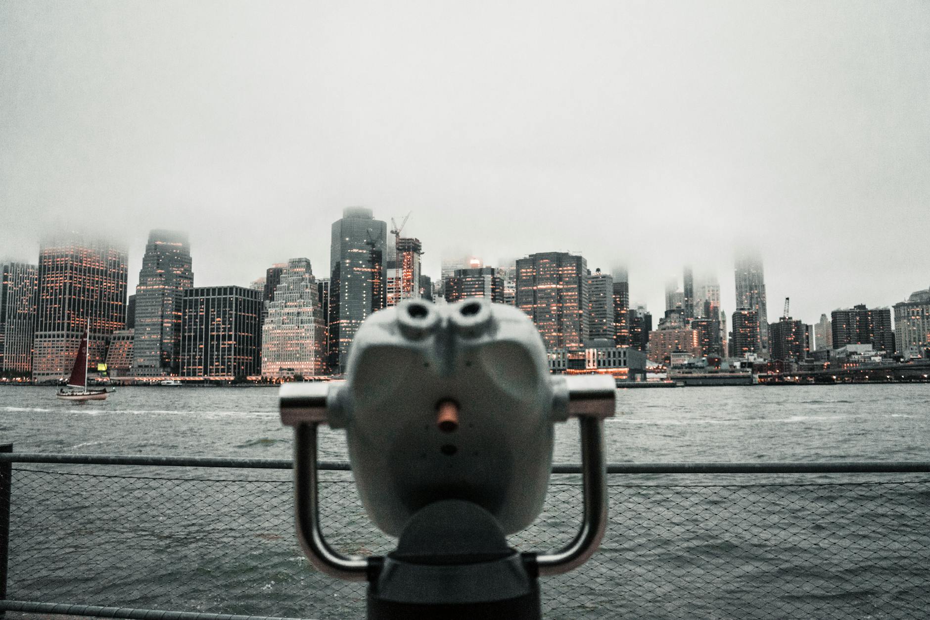
I do not know of a genre of music that would exclusively identify with the suburbs. As Americans moved to the suburbs in large numbers in the twentieth century for numerous reasons, music changed in the United States as well. This included new genres, new methods for playing and hearing music, and new audiences. And all of this happened on a mass scale; music could be produced, played, and listened to for and by millions of people.
Hot adult contemporary (hot AC) radio stations play a wide range of popular music that appeals towards the 18–54 age group;[43] it serves as a middle ground between the youth-oriented contemporary hit radio (CHR) format, and adult contemporary formats (such as “mainstream” and soft AC) that are typically targeted towards a more mature demographic. They generally feature uptempo hit music from the last 25 years with wide appeal, such as pop and pop rock songs, while excluding more youth-oriented music such as hip-hop.[42][41] Older music featured on hot AC stations usually reflects familiar and youthful music that adults had grown up with.[44][41] Likewise, material from legacy pop acts such as the Backstreet Boys, Jason Mraz, John Mayer, and Pink is prominent within the format.[41][40]f
Pop music of the last few decades for 18 to 54 year olds is suburban music? Maybe more so than some other formats.
(The other part of this station’s tag line is that they broadcast from the ‘burbs. This contrasts with the majority of the radio stations in the area that identify with the big city.)
Three people have lived in the deserted cathedral in the past two years, with each occupant — an electrician, a sound engineer and a journalist — paying a monthly fee to live in the priest’s quarters.
The cathedral is managed by Live-in Guardians, a company finding occupants for disused properties, including schools, libraries and pubs, across Britain. The residents — so-called property guardians — pay a fixed monthly “license fee,” which is usually much lower than the typical rent in the same area…
The practice of populating disused properties with guardiansis unregulated in Britain and comes with fewer legal protections for the residents than renting. Guardians have also complained of inconveniences and outright hazards, such as no access to drinkable tap water and rickety ceilings…
The practice started in the Netherlands in the 1980s and has long attracted artists, musicians and other creatives in search of enough square footage to do their work, as well as those prepared to live more precariously. For example, in Britain, guardians can be asked to vacate the property with 28 days’ notice, compared with the two months afforded to most private renters…
The UK housing ministry states in its guidance on guardianships that it “does not endorse or encourage” the practice because people “can be asked to live in conditions that do not meet the standards of residential properties.”
This seems like a short-term solution to two big issues facing a number of cities. Where is the affordable housing? How might older but unused buildings be preserved or used again? Each issue is complex. Each would take a long time to address.
In the meantime, what truly happens to these buildings? It seems like they have some use but given the stories shared here, it sounds like they are slowly deteriorating.
And what are the experiences of residents? Based on what is shared here, it sounds like it might be a less than positive experience overall as people are able to get by and not much else.
Are there any cities in the United States that have similar programs and, if so, what are the outcomes?
It is easy to find headlines regarding cities and U.S. Immigration and Customs Enforcement raids. But, reading a number of these stories shows these are also happening in suburbs. This one story detailing locations across the United States includes these suburbs:
Or see this story of operations in Chicago area suburbs.
These are suburbs of major metropolitan areas. Cities may be the target of particular political ire but there is less recognition that many people who come to the United States live in suburbs (or rural areas).
And how will suburbs respond to these federal efforts? When migrants were sent to suburbs of Chicago in 2023 from other locations in the United States, few suburban communities were interested in having them stay (see posts here, here, and here). A number of big cities have announced how they will respond but there are thousands of suburbs in the United States.
In Sanctifying Suburbia, I look more closely at the locations of the National Association of Evangelicals in Chapter 4. As a group that purported to represent the interests of a growing evangelical movement from the 1940s onward, where did they locate their headquarters?
For decades, their headquarters were in two adjacent suburban communities roughly 25 miles from Chicago: Wheaton and Carol Stream. These two suburbs contain a cluster of evangelical organizations (discussed further in Chapter 5 and 6 of the book). In the late 1950s and early 1960s, the NAE had multiple locations in downtown Wheaton. According to the local phone books, their location in 1957 was 108 N Main. Here is a Google Streetview image of that address from June 2019:
This is the same block that was briefly shown in a Walmart Super Bowl ad a few years ago. When I walked past the location earlier this week, the building is undergoing a massive renovation.
In the 1960s, the NAE moved a few miles north to Carol Stream. They concluded their time in the suburb in an office building within an office and light industrial area. Here is what the property looked like a few years ago (a Google Streetview image from October 2016):
The organization was there until 1999 when they had a short sojourn to suburban southern California before moving the headquarters to Washington, D.C. in 2002.
These headquarters fit in a suburban landscape, the first in a two story brick building in an older suburban downtown with the second looking like many other small office buildings dotting suburbia, with little more than a sign marking them as spaces occupied by a religious organization. And from these suburban locations, the National Association of Evangelicals supported a growing evangelical movement across the United States.
Between Manhattan and West Egg, where Jay Gatsby and Nick Carraway live, spreads the “valley of ashes,” “a fantastic farm where ashes grow like wheat into ridges and hills and grotesque gardens; where ashes take the forms of houses and chimneys and rising smoke and, finally, with a transcendent effort, of men who move dimly and already crumbling through the powdery air”. Fitzgerald’s valley of ashes tips its hat to TS Eliot’s The Waste Land, but it was also a feature of New York at the time. The Ash Dumps were mountainous piles of ash up to 90ft high, a malodorous stretch of swampland in which coal ash, cinders, garbage, and human waste had been dumped. Lone figures wandered the desolate heaps searching for treasure or anything they could sell – a perfect image of a nation squandering its promise in search of a buck.
Most of the novel’s memorable details function in the same way, as realistic features of New York in 1922, and as symbols that fuse social satire with the novel’s metaphysical meanings. Gatsby is peppered with familiar symbols: the valley of ashes, the green light, the eyes of Dr Eckleburg that are mistaken for the eyes of God. It’s a novel that understands how signs can expand our capacity for thought. Gatsby’s green light has become one of the most famous images in literature, standing for Gatsby’s envy of the Buchanans’ world and his desire to attain it. It suggests his and his nation’s aspirationalism, their faith in renewal, in the fresh hope of starting over – and their drive for the colour of American money…
Hollywood routinely helps itself to any details from the 1920s that let it gesture toward the jazz age. Baz Luhrmann’s 2013 film adaptation of Gatsby features Prada dresses in silhouettes that were not worn until around 1928. This may sound like pedantic quibbling – what’s six years in Hollywood time? But, socially and culturally, the 1920s ended in a very different place from where they began: the styles of 1922 were far closer to those of 1919 than to those of 1929.
Luhrmann’s Broadway is thronged with yellow taxis – but New York taxis were not uniformly yellow in the early 1920s. There were also red taxis, blue taxis, checkered taxis, and by the summer of 1923, lavender taxis, like the one Myrtle Wilson selects after letting four others pass by. Lavender taxis were known for being expensive and could seem pretentious, an impression heightened by their violent colour scheme: “cerise and lavender taxis with red and green checkers”. A night out in Prohibition New York, it was said, “begins in a bierstube [beer hall] and ends in a purple taxi”. Myrtle Wilson, with her violent affectations and social climbing, would naturally choose a lavender taxi.
These deadening clichés distort our view of Gatsby in important ways. They keep us from registering how rich and strange and alien its world is: the New York of Gatsby lures us in because it is a surreal and surprising city, without a trite yellow cab in sight – but a lavender one is waiting for those who care to notice. All these carefully chosen details also suggest a world beyond the merely mimetic – what John Updike once called the ability of language to be “worked into a supernatural, supermimetic bliss”. The reason everyone who reads Gatsby wants to join the fun has far less to do with our ideas of what a jazz-age party looked like than with the vital strangeness of Fitzgerald’s writing. The lavender taxi is hyper-realistic, but it is also surrealistic, capturing the phantasmagorical qualities of Gatsby’s New York.
Trying to remember the past of familiar places can be difficult. Images and narratives about New York City are so widespread and pervasive that they can be hard to counter. Was Times Square always that way? What about Harlem or Brooklyn?
Cultural works that try to do this can add to the difficulty. Did they portray things correctly? What sources are they drawing on? How many people engaged with that cultural work (whether it was accurate or not)?
Are there sites devoted to pointing people to correct depictions of places in the past and telling them which ones to avoid? For example, this article points out that Fitzgerald captures some unique features of early 1920s New York while the 2013 film does not. If I wanted to know more about New York as it was, should I watch the Godfather or find other sources?
Paramus officials say they’re exploring a lawsuit against American Dream, after learning that retail shops at the Meadowlands megamall are open for business on Sundays in defiance of Bergen County’s Blue Laws.
The stores at American Dream have been operating in violation of those laws for nearly a year, The Record and NorthJersey.com reported last week, despite the county’s longstanding prohibitions against the sale of nonessential items such as furniture, appliances and clothing. The restrictions, in place since the 17th century, exempt some services, including groceries and drugstores.
Paramus residents in particular have been proponents of the Blue Laws over the years. Supporters say they grant them a day of reprieve from heavy traffic that plagues the town the rest of the week due to the borough’s four malls…
“Being mayor of Paramus, I know how important the Blue Laws are to our way of life and the peacefulness of Sundays,” he said in an interview. “[It gives us] the ability to move around town, the ability for our emergency services to have less calls and regroup. As mayor, I’m going to fight like heck for Paramus and the county as a whole.”
Such regulations used to be more common across the United States. It can be surprising for some to hear that places would continue to follow these guidelines or businesses might choose to follow them (see some of the conversations around Chik-Fil-A in different parts of the country regarding their practice of not being open on Sundays). Even the article above notes that these restrictions date back hundreds of years; are these simply archaic local idiosyncrasies?
The explanations given by these suburbanites regarding the purposes of the blue laws are interesting in today’s context. Is Sunday a day of rest from traffic? Are the malls bringing in so many vehicles from outside the county that their closure on one day makes it easier for locals to get around? Do the EMTs and police need time on Sunday to regroup from all of the accidents and calls on the other six days of the week? The website of another suburb in the county highlights the Sunday prohibitions but does not say why they exist.
My guess is that the Bergen blue laws originate in religious motivations. Sunday is the Christian day of rest. I wonder how much of the current support for the blue laws is religious support as opposed for other reasons for having a day of rest.
Many municipalities in the United States want more local revenue. Having multiple local shopping malls is a good thing because it can increase commercial activity and sales tax revenues. Can communities still thrive if they limit shopping mall activity on one of the weekend days?
Map lines are inherently political. After all, they’re representations of the places that are important to human beings — and those priorities can be delicate and contentious, even more so in a globalized world where multiple nations often share the same maps.
Numerous examples follow:
The water bordered by the Southern United States, Mexico and Cuba will be critical to shipping lanes and vacationers whether it’s called the Gulf of Mexico, as it has been for four centuries, or the Gulf of America, as President Donald Trump ordered this week. North America’s highest mountain peak will still loom above Alaska whether it’s called Denali, as ordered by former President Barack Obama in 2015, or changed back to Mt. McKinley as Trump also decreed…
The Persian Gulf has been widely known by that name since the 16th century, although usage of “Gulf” and “Arabian Gulf” is dominant in many countries in the Middle East. The government of Iran — formerly Persia — threatened to sue Google in 2012 over the company’s decision not to label the body of water at all on its maps. Many Arab countries don’t recognize Israel and instead call it Palestine. And in many official releases, Israel calls the occupied West Bank by its biblical name, “Judea and Samaria.”…
The Associated Press, which disseminates news around the world to multiple audiences, will refer to the Gulf of Mexico by its original name while acknowledging the name Gulf of America. AP will, however, use the name Mount McKinley instead of Denali; the area lies solely in the United States and as president, Trump has the authority to change federal geographical names within the country.
Humans make meaning of the world around them and maps capture some of that meaning. And because meaning is sometimes agreed upon and sometimes contested, maps reflect these realities.
What are innovative ways to include multiple names or meanings on a map? Or layer changes in a map over time? I have seen some interesting displays online that attempt to do this. How can maps be more dynamic and flexible?
Are city streets places for pedestrians to hang out, or are they routes to be traversed as quickly as possible?
Americans are increasingly treating them as the latter rather than the former.
That is the striking implication of a recent interdisciplinary study published by the National Bureau of Economic Research. Applying modern artificial intelligence techniques to old video footage, the researchers compared pedestrian activity in 1980 and 2010 across prominent locations in Boston, New York City and Philadelphia. Their unsettling conclusion: American ambulators walked faster and schmoozed less than they used to. They seemed to be having fewer of the informal encounters that undergird civil society and strengthen urban economies…
Salazar-Miranda said that video analysis alone cannot explain why pedestrian behavior changed, but she sees several possible factors. Since average incomes rose among those who lived and worked near all four locations, individuals’ higher value of time could deter them from engaging in leisure activities like casual conversation or strolls that now carry a higher opportunity cost. City dwellers might be having fewer social interactions of all kinds, a phenomenon that has been linked to rising rates of loneliness. And some of the pedestrians observed in 2010 could have been socializing remotely: By then, 80% of US adults had cellphones. Mobile devices may be inducing people to hang out online instead of in person. Salazar-Miranda suggested those who do get together might opt for climate-controlled, pay-to-enter “third spaces” like coffeeshops that she said have become more widely available.
I have heard some similar research presented before and I like the methods of comparing videos of city streets decades ago to observations today. Changes over time are important to consider as cities and societies change.
At the same time, I wonder about how to think about fewer interactions on city sidewalks to societal changes overall. If broad arguments in Bowling Alone and similar work are correct that Americans are engaging civically less over time, would we expect to see fewer interactions on city sidewalks and in suburban parks and rural communities? If phones are everywhere, are they affecting people in different places in different ways? Showing that city sidewalks were once one thing and are now something else is important but what if social interaction between strangers or in public has dried up in all places? Is this evidence similar or different to conversations about kids of the 1970s playing outside all the time and big changes since then?
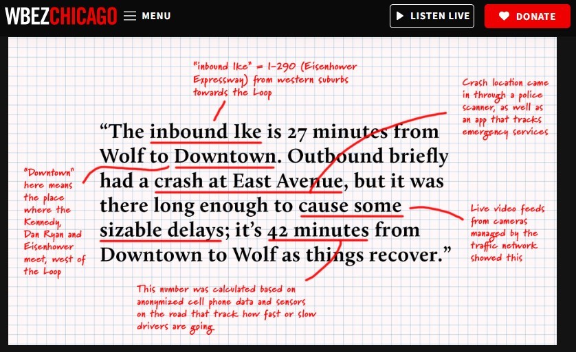
Listen to or watch or read Chicago traffic reports and “downtown” is likely to come up. Here is what that refers to:
In Chicago, the downtown is like it is in the many big cities: it is the central business district, marked by skyscrapers and business activity. Downtown and the Loop – marked by mass transit lines – are pretty synonymous. The Loop is one of the city’s 77 community areas that have been defined for decades.
But the downtown referenced above is outside the Loop. It is across the Chicago River. It is marked not by financial matters but by the convergence of highways. It arose on top of existing neighborhoods. This is technically the Jane Byrne Interchange, a busy location where people are driving in and out of the city. Depending on traffic, it can take a while to get from this location to downtown.
While they are not the same place, this sounds very American: the center of the city is actually where the most vehicles meet. As so much day-to-day life involves driving, perhaps this is downtown for many.
I recently found a list of wealthy American with the most population growth. But I noticed that the list ends with two suburbs that lost population during the time period of interest (2018-2023). I suspect this might be because how they selected the communities on the list.
Methodology: For this study, GOBankingRates analyzed suburbs to find the fastest-growing wealthy suburbs in America. First GOBankingRates found the places with a population between 25,000 and 100,000 according to the U.S. Census American Community Survey. The metro area for each location was found and only the metro areas with a population of 1 million or more were kept. With these suburbs isolated, the numerical and percentage change in population from 2018 to 2023 were found for each city using data from the American Community Survey Census from 2018 and 2023. For each location, GOBankingRates found total population, population ages 65 and over, total households, and household median income all sourced from the American Community Survey. Only places with a median household income of $150,000 or more were kept for this study. Using this data the percentage of the population ages 65 and over were calculated. The cost-of-living indexes were sourced from Sperling’s BestPlaces and include the grocery, healthcare, housing, utilities, transportation, and miscellaneous cost of living indexes. Using the cost-of-living indexes and the national average expenditure costs, as sourced from the Bureau of Labor Statistics Consumer Expenditure Survey, the average expenditure cost for each location were calculated. The livability index was sourced from AreaVibes for each location and included as supplemental information. The average single-family home value was sourced from Zillow Home Value Index for November 2024. Using the average single-family home value, assuming a 10% down payment, and using the most recent national average 30-year fixed mortgage rate, as sourced from the Federal Reserve Economic Data, the average mortgage can be calculated. Using the average mortgage and average expenditure costs, the average total monthly and annual cost of living were calculated. The cities were sorted to show the highest percentage population increase first to show the places with the fastest-growing wealthy suburbs in America. All data was collected on and is up to date as of Jan. 6, 2025.
The bigger question is this: how many suburbs in the United States of population 25,000 to 100,000 have median household incomes over $150,000? I suspect this is not a huge list. Hence, there are only 28 suburbs who meet this criteria and grew between 2018 and 2023.
But it may not take much to change the parameters to include more suburban communities on the list. For example:
What if the median household income was $140,000? Is there a strong reason for leaving the cutoff at $150,000?
Why limit the population to communities between 25,000 and 100,000? If the list could includ communities between 10,000 and 100,000, are there now more growing wealthy suburbs?
Limiting the analysis to metropolitan areas with 1 million people reduces the number of possible regions and suburbs. If the cutoff is 1 million people in an MSA, this means a little over 50 regions are included. Lower the region’s population and you would have more suburbs that might meet the criteria.
Change the list from 30 suburbs to 20 and then the last one on the list would have 5% population growth.