The origins of this devil-may-care approach to development stretches back decades. “One of the things we’re going to look at is all that development in the 60s, 70s, and 80s, where we just sprawled out along the highways, built office complexes in the middle of nowhere, and built these five acre McMansions on farm fields. With all those policies, we’re going to have to reverse them at some point where we need to develop in a smarter, better way: places that are more walkable, fewer cars, more green space, less pavement. It’s not going to be easy because we, in some ways, have to fix the mistakes of the past, like on stormwater, where so many of our cities and towns are already paved, how do you go back and retrofit them? How do you break up these heat island effects in places like North Jersey? With planting trees, putting in more green space, green roofs, and stuff like that. That’ll take some money and it takes political will in New Jersey. I’ll just say that we have a flood of problems and a drought of action on some of these issues. We need to have the political will to make some of the tough choices and then make those kinds of investments. So far, we just keep kicking the can down the road.”
By the 1960s, Americans had a history of suburban homes stretching along railroad lines, streetcars lines, and roads. The ideal of the single-family home was well established. Plenty of people had fled cities. New transportation options provided speed and opened up new land for development.
Reversing these significant changes will require significant shifts in different directions plus time. Forget New Jersey; would Americans as a whole, particularly the majority of residents who live in suburbs, want to reverse these patterns or do they enjoy suburban life (or dislike the alternatives) so much that they would resist major changes? Either way, the consequences of sprawl will continue to affect society for decades to come.
An NBA Playoffs commercial touting “playoff mode” includes the line “from suburbia to Serbia, it’s unbelievable” alongside this image of suburban basketball:
What stands out in this depiction of suburbia? A few things:
Outdoor basketball with palm trees on a beautiful day of sunshine. Is this southern California? I assume this is a good spot to play basketball outdoors for most of the year. Not all places in the United States can claim this.
This is a hoop in the driveway of a single-family home. The two players are not at the park playing basketball; they are playing in a private setting (though the street is presumably just out of view).
How many players can dunk on the hoop set up in their driveway? It is hard to tell from the angle of the shot – the camera is just a foot or two off the ground – whether the hoop is at ten feet.
It does look like fun is being had with two guys playing hoops in the American suburbs…or a studio backlot made to look like one. While the line in the commercial tries to drive home the appeal of playoff basketball in two places with alliterative names, are the driveways of the American suburbs one of the key sites for basketball?
Tuesday’s electoral results show in miniature the national Republicans’ weakening grip on the suburbs. Come November, the race will also be a key post-midterms bellwether for both parties. Democrats made big gains in suburbs nationally in 2018 and 2020.
Nowhere else is that more apparent than Carmel. Slowly, this city has become more diverse and seen an influx of younger, more moderate voters who flock here for its award-winning school system, public art, affordability and culture (it’s home to a $126 million concert hall drawing national acts like the singer and songwriter Jason Isbell, and boasts more than 138 roundabouts, more than any other city in the U.S.). Students of the public school system speak 65 languages from 55 countries. Though many of its communities are gated, it’s not been walled-off from social change: Black Lives Matter marches snaked down the Monon Trail in Carmel amid $1 million townhouses and an upscale steakhouse in the summer of 2020…
Now, the Indiana Democratic Party is eyeing Carmel as a potential pickup this November. Mike Schmuhl, Pete Buttigieg’s former campaign manager and the state party chairman, is targeting this suburb in hopes of flipping it blue.
“The city has changed a lot,” Schmuhl said over lunch today at Fat Dan’s Chicago Deli in Carmel. “This used to be a rock-ribbed, Republican, conservative area but the Republican Party has changed a lot, too. So what you have up in Carmel is a lot of development, a lot of families, educated voters, hard working people, and the Democratic Party’s values appeal to those people.”
As someone who studies suburbs, four things I would note about Carmel that are relevant for this story:
It is regularly named a Best Place to Live in Money’s list.
It is right outside the combined Indianapolis-Marion County unigov arrangement. While that move was intended to help the city capture some suburban growth, Carmel sits right outs Marion County in neighboring Hamilton County.
The population growth since 1960 has been astounding as it had just less than 1,500 residents in the 1960 Census. The suburb has had more than 25% population growth every decade since then and now has just under 100,000 residents.
It has plenty of white-collar jobs due to corporate headquarters and offices.
The number of suburbs – or communities overall – that look like Carmel is small. At the same time, these larger suburbs have a higher status ad get more attention. As the political parties continue to fight over suburban voters, pundits will continue to look to growing and changing suburbs to see which ways the winds are blowing.
But perhaps nothing drives home the impact of Secretariat’s life more than looking at a map. Like, any map. We know because we’ve looked at them. All of them. In an effort to identify roads in the U.S. named for athletes, ESPN cross-referenced 2010 Census data with Google Maps. We were stunned to uncover 263 roads named after the horse — far more than for any other athlete, human or otherwise. “I’m not that surprised,” says Kate Chenery Tweedy, whose mother, Penny, raised and owned Secretariat. “Secretariat came along at a time of great crisis in this country — Watergate, the Vietnam War, Nixon’s impeachment. And unlike any other athlete ever has, he restored our sense that there is beauty and good in the world.”…
Born in Virginia. Won Triple Crown races in Kentucky, Maryland and New York. So it makes perfect sense that the states with the most Secretariat streets are … Florida and Texas?…
Road experts say there is little rhyme or reason to the way our streets get their names. It’s mostly just real estate developers who submit names to their town, there’s usually a relatively easy approval process, and voilà. Case in point: Somebody in Butte, Alaska, sure likes horse racing. You can take Sea Biscuit Lane to E. Man o’ War Drive, then hang a right onto E. Secretariat Drive — the most northerly road named for Secretariat. And if you wanted to ride Secretariat the 3,920 miles back to his burial site? At the record 37.8 mph he ran the Belmont in, he’d have gotten you there in a little over four days.
As someone who studies suburbs, here is my own theory for this naming pattern. Developers often want names for nicer subdivisions connected to tradition, certain lifestyles, and success. Why not reference both horse racing and one of the most successful horses ever? Horse racing requires money to participate and the audience for horse racing might fit particular demographics. Additionally, horse racing hints at nature. Secretariat is a well-known athlete. Such names will help establish their subdivision as an exciting place for people with means.
My own community has at least a few street names that connect to horse racing. This is not just a connection to racing in the abstract; our suburb has links to horse racing near these sites with a racetrack that was in existence in the early 1900s and another farm with wealthy owners who bred and raced horses in the second half of the twentieth century.
By linking single-family homes to horses and one of the most famous American athletes, how can a developer go wrong?
Taiwan-based Foxconn Technology Group forged an agreement in 2017 with former Gov. Scott Walker to manufacture LCD screens in Mount Pleasant, investing $10 billion and employing 13,000, in return for billions in subsidies. But the company, a top manufacturer of Apple’s iPhones, downsized its plans and created few jobs, forcing government officials to find other users.
Data centers process and store huge volumes of computer data, forming the backbone of the internet. Although these facilities typically don’t create large numbers of permanent jobs, local leaders and tech experts say Microsoft’s arrival signals the Foxconn land, along with infrastructure improvements already complete, won’t go to waste…
Residents on the land promised to Foxconn were displaced from their homes, but the company, blaming “unanticipated market fluctuations,” canceled the mega-factory. In 2021, it signed a new deal with Gov. Tony Evers, who beat Walker after criticizing the original agreement. Instead of up to $3 billion in subsidies, Foxconn agreed to collect $80 million for creating 1,454 jobs and investing $676 million in a set of smaller facilities by 2026.
Microsoft’s agreement with Mount Pleasant and Racine County requires it to launch construction by 2026. The company can recover 42% of its property taxes, but no more than $5 million per year. The local governments can also repurchase the land at the same price if Microsoft fails to hit the deadline.
The logic for this is provided in the story. Attracting big companies and jobs is viewed as important. If growth does not come here, it will go to other communities who will benefit. The deal with Foxconn fell through but having some deal and a few jobs is better than nothing. Growth must continue as must the tax breaks.
Do they really have to continue in this fashion? The final paragraphs hint at one of the possible motivating factors for these companies locating in southern Wisconsin: they are just over the Illinois border and can service the Chicagoland region. If Chicago area municipalities will not compete with each other in these same ways, just go over the border and find plenteous tax breaks. Another motivating factor seems to be a fixation on big companies and tech companies. What community would not want to boost they have a Microsoft facility (even if it is just a data center)?
I hope some people keep following up this story and similar ones to find out what communities and residents actually get out of these tax break deals. How much is spent per job? How does the business growth help the community? What does a data center contribute to a community? Years down the road, who benefits the most from these deals?
-Always be aware of your surroundings. Do not walk distracted to the point where you do not know what is going on.
-Take in and enjoy what is going on around you involving people, buildings, nature, and more.
-Keep at the speed of other pedestrians around you. There are times to go slower (strolling areas, tourist areas) and times to go faster (going with rush hour traffic to the train station). Know the purpose of your walk and act accordingly.
-Do not stop suddenly in the middle of walking.
-Do not block the middle of a walking path.
-Anticipate the actions of others, particularly vehicles.
-Be clear and decisive in your movements. Do not make others guess at your intentions as a pedestrians.
-Make eye contact with drivers.
-If walking in a space shared with vehicles, walk against traffic and stay to the side.
For almost three hours, crews from Fernandez Tree Service hacked away at one of Chicago’s oldest trees, a centuries-old, sprawling bur oak that had reached the end of its life span. The nearly 70-foot giant was here long before the zoo was built in 1868, when the area was just a lakeshore covered with tall grass, and possibly even predating the incorporation of the city of Chicago.
Director of horticulture at Lincoln Park Zoo Katrina Quint said the tree is 250 to 300 years old. The caramel cross-sections of the trunk have diameters of 60 inches…
Scott said that in northeastern Illinois, about 1 million acres of land used to be oak forests. There are only 17% of those oak ecosystems left, and 70% are in private ownership, meaning that they’re not in protected status, she said…
Morton Arboretum’s Robert Fahey wrote about this native species loss in the 2015 Oak Ecosystems Recovery Plan, led by the Chicago Wilderness and the Oak Ecosystems Recovery Working Group. Fahey overlaid 1830s public land survey data with 1939 aerial photography and 2010 analysis to see where oak ecosystems used to exist and where they exist now.
The Chicago area now has many trees, but losing one of its oldest trees both harms the ecosystem and severs a connection to the past. Trees are an important part of the landscape and can outlive development and people.
One thing that cities and suburbs tend to do is level the landscape, plop buildings, roads, and more on the ground, and place all sorts of infrastructure underground. It is hard to imagine that prior to the Chicago region, there existed sand dunes, waterways that operated differently (the Chicago River, in particular), groves of trees, swamps, and prairie spaces. The growth of Chicago was bad news for these natural settings as the city consumed land and resources, produced much pollution, and recreated “nature” along the lakefront and in parks.
I hope more people can see what areas looked like before mass development in the United States. This can help prompt thinking and action about what we might do with land beyond building houses and providing pathways for vehicles.
Their large five bedroom property with a sprawling 200 metre-long drive is located in The Ponds area in west Sydney, where hundreds of new homes have popped up in recent years…
The home looks bizarrely out-of-place wedged between identical chock-a-block newbuilds, where its 1.99 hectare garden could fit over 50 of the matching new homes inside.
However, when their neighbours upped and left – choosing to sell to the developers – the Zammits made a last hold out.
They refused to sell, despite being offered millions, and prevented the developers snatching up the last plot of land.
“The fact that most people sold out years and years ago, these guys have held on. All credit to them,” local agent Taylor Bredin told 7News…
In short, the land could be worth over £25million, especially after ten years of their private rebellion.
The valiant resident holds on to their land despite possible riches; all they have to do is move. Such a story fits the image of the sacrosanct property owner. A home is their castle. No one can tell them what to do. If they want to stay, they can stay. The government or private actors should not be able to move them.
At the same time, we believe growth is good. If even just a few property owners hold out, they can interrupt larger plans for new buildings and activity. Imagine an important highway project or mass transi line or new tall building that need several properties to make it better for others but those owners will not sell. Are there limits to whether a property owner can hold on?
In the Seattle story referenced by Up and in this Australian suburban story, developers could not force the issue but they could build right around them. Edith Macefield’s Seattle home was boxed in on three sides. The suburban property above is surrounded on all four sides by dense single-family homes. The property owner has stayed but the surrounding area has been radically transformed.
I get why. It is indeed tempting. The kids are running around and occupied. Their activity means that parents might have a few moments to themselves. The park often has benches or places to relax. Why not catch up on some texts or social media activity?
Even without kids around, parks feature plenty of phone use. Walk the dog and read the phone along the way. Try biking and phone use together. Lots of walking with earbuds in or headphones on.
However, parks can be inherently interesting places without phones. Kids are learning and developing skills. There are often hints of nature around, birds to spot, bodies of water to observe. There is plenty of people-watching to be done. If the park is a lively one, perhaps one envisioned by Jane Jacobs where people are using it in multiple ways and it is situated among other interesting uses, there is plenty to see and do.
(To be fair, adults are on their phones all over the place. I have just noticed it recently in parks amid my own efforts to use my phone less in this setting.)
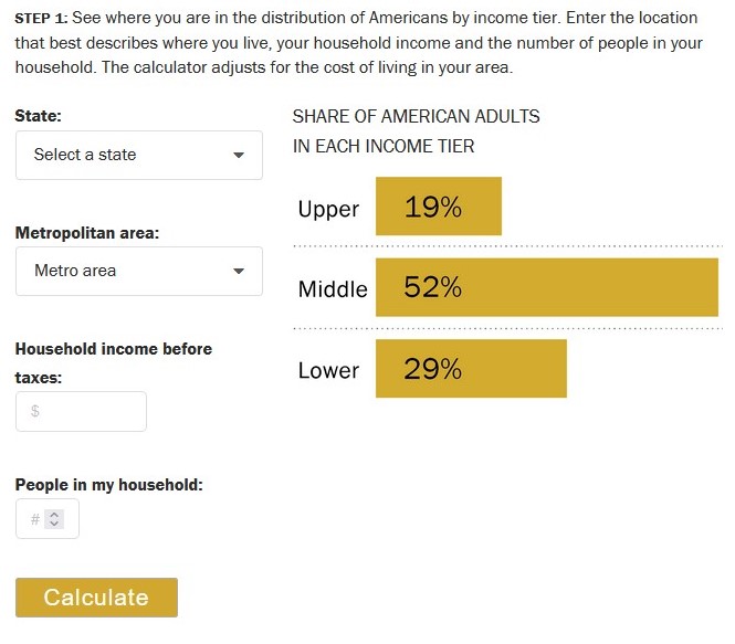
The calculator takes your household income and adjusts it for the size of your household. The income is revised upward for households that are below average in size and downward for those of above average size. This way, each household’s income is made equivalent to the income of a three-person household (the whole number nearest to the average size of a U.S. household, which was 2.5 in 2018)…
Your size-adjusted household income and the cost of living in your area are the factors we use to determine your income tier. Middle-income households – those with an income that is two-thirds to double the U.S. median household income – had incomes ranging from about $48,500 to $145,500 in 2018. Lower-income households had incomes less than $48,500 and upper-income households had incomes greater than $145,500 (all figures computed for three-person households, adjusted for the cost of living in a metropolitan area, and expressed in 2018 dollars).
The following example illustrates how cost-of-living adjustment for a given area was calculated: Jackson, Tennessee, is a relatively inexpensive area, with a price level in 2018 that was 19.0% less than the national average. The San Francisco-Oakland-Hayward metropolitan area in California is one of the most expensive areas, with a price level that was 31.6% higher than the national average. Thus, to step over the national middle-class threshold of $48,500, a household in Jackson needs an income of only about $39,300, or 19.0% less than the national standard. But a household in the San Francisco area needs a reported income of about $63,800, or 31.6% more than the U.S. norm, to join the middle class.
Key here is the idea that incomes go further in some places and have less purchasing power elsewhere. By itself, income may not be that great of a measure for determining social class. Including location helps get at local variations in class.
Of course, there are other factors that go into assessing social class. This includes education, wealth, social networks, and more.
(Note: this calculator is based on 2018 data so there could be some important changes here in 2023.)