No need to use local landmarks while driving

I have read a number of local and metropolitan histories recently and some of these books include driving or walking tours. The tours guide readers through several hours of driving across suburban communities to see key sites and scenery or along walking paths through a community or neighborhood.

Photo by David Brown on Pexels.com

To direct people on the tour and help them understand the local landscape, the texts rely on local landmarks. See an important civic building or a church or cross a river and then turn. They mark important memories or groups or features of a community. Even someone unfamiliar with the community might get a sense of a landmark’s importance from its prominence or scale or the way people interact with it. There are mileage markers – such as travel 1.3 miles on a particular road – and some wayfaring via finding particular roads and intersections. But the tour is geared around meaningful local places and buildings. The landmarks are an important part of the tour and they help the touring party make it to the next stage. Without such landmarks, what would people on the tour pay attention to and how would they know where to go?

This way of navigating was not confined only to tours. If you needed to get from place to place, you could work with landmarks, signs, and people to get where you needed to go.

This strategy of finding one’s way through a place via landmarks is gone. A good road map with local roads – and not one that primarily relies on major highways and interstates – could replace a step by step tour guide.

But a GPS system really ends it. If the goal is the quickest or most efficient route, that path may or may not pass by local landmarks. Because many important buildings or local places are located along major roadways, you might still see landmarks. But you do not really need to pay attention. A driver can focus on the map screen and the next direction given. It almost does not matter what is going by outside the vehicle windows; it is what is happening on the way to the next step.

Automated driving or touring could free up people to be better observers of the world around them. I am not sure it has worked out that way.

ADDED 10/1/26

Thinking more about this post, I was reminded of a scene from Season 4 of The Office:

GPS: Make a right turn.[Michael starts to turn right]

Dwight Schrute: Wait, wait, no no no, it means “bear right.” Up there.

Michael Scott: No, it said right. It said take a right.

Dwight Schrute: No, no. Look, it means go up to the right — bear right — over the bridge, and hook up with 307.GPS: Make a right turn.

Michael Scott: Maybe it’s a shortcut, Dwight. It said go to the right.[he turns right]Dwight Schrute: It can’t mean that, there’s a lake there!

GPS: Proceed straight.

Michael Scott: I think it knows where it is going.

Dwight Schrute: This is the lake! THIS IS THE LAKE!

Michael Scott: The machine knows! Stop yelling at me! Stop yelling!

Dwight Schrute: NO! IT’S UP THERE! THERE’S NO ROAD HERE![It’s too late. Michael drives right into the lake]

Dwight Schrute: Remain calm, I have trained for this![he unbuckles his seat belt]

Dwight Schrute: Okay. Exit the window! Here we go![Dwight and Michael climb out the windows]

GPS: Make a u-turn, if possible.

You do not need landmarks, like lakes, if the GPS voice is telling you where to go.
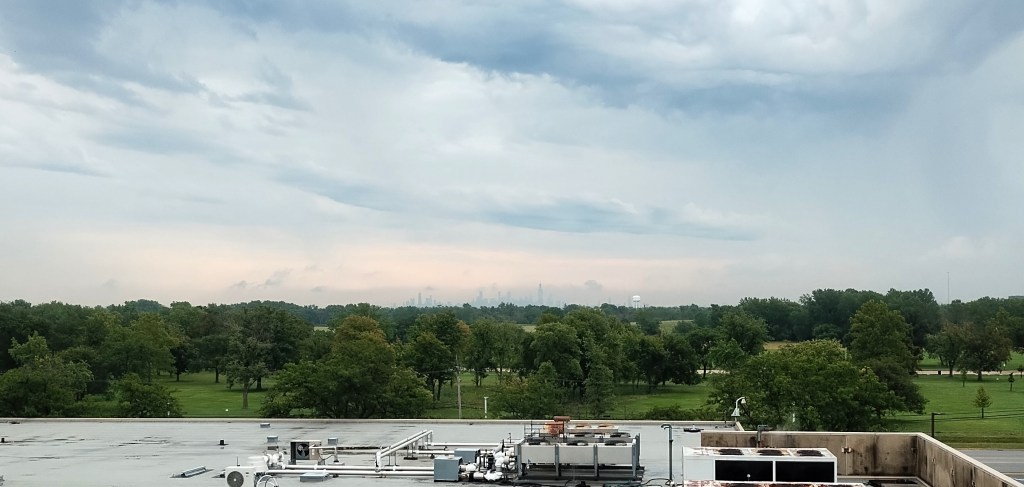
Living with a distant view of a big city’s skyscrapers

My daily life in the suburbs does not provide views of the Chicago skyline. But I do not have to go far to find such views. Here is one recent example looking east from a four story building:

Given the importance of skyscrapers for cities, how do these skylines affect suburbanites? They may provide a reminder of the big city. They may be a landmark or anchor in looking in a particular direction. They could be interesting to view amid changing weather conditions (as I was watching the image above, rain was coming down off and on in between my location and the skyline). They could provide space where a suburban resident works.

Such buildings are relatively rare in the suburbs. There are collections of taller buildings in suburbs, particularly in communities with office parks. This can occur in edge cities where buildings provide hundreds of thousands of square foot of office and retail space near major roadways. But this buildings are rarely 50+ stories and they cannot be seen from as far away as a skyline like Chicago’s.

I think I would enjoy seeing a distant skyline on a regular basis. It might feel less like a looming structure and more like a reminder of the population center nearby. To see multiple tall skyscrapers in one view provides a reminder of the large scale of human activity in the early 21st century.

How many landmark buildings should a suburb have?

As Napervillians debate the fate of the Scott house, a 156-year-old home constructed by one of the community’s first families, the number of historic landmarks in the suburb stood out:

Photo by Tim Mossholder on Pexels.com

As things stand right now, there are no protections that would prevent future owners from altering or tearing down the house. Its location is just outside of the Naperville Historic District, where regulations dictate standards for exterior home improvements. It is part of a federal historic district, but their rules is not nearly as restrictive, according to the Illinois Historic Preservation Office.

Preservation is possible were it to be made a city landmark, a process open to any Naperville property over 50 years old, but that requires the recommendation of the Naperville Historic Preservation Commission and the approval of the Naperville City Council.

There are only four historic landmarks in Naperville.

Heap said he and his fellow co-owners are keeping options open but acknowledges the house’s future will hinge on who it’s sold to. That also goes for whether Heap’s law practice stays on as tenants.

This is not a new debate in Naperville. As the article notes, the suburb has a historic district that developed over time and through much discussion. Naperville has lots of teardowns where public debate could pit the property rights of the owners against the interests of neighbors or the community.

Is four historic landmarks, then, good or enough? The current four include two houses, one former church, and a former library building. One way to figure this out would be to do some comparing to other suburbs. I do not know these figures but someone or an organization might have them. Another way to think about it is that Naperville has a track record of preserving its past and telling its own story, such as through Naper Settlement and other actors. A third option would be to have some sense of what leaders and residents want concerning landmarks; do they want to save particular structures or have guidelines for more buildings and properties?

The matter of preserving buildings in the suburbs is an ongoing conversation as buildings from a prior era come up against changing conditions and styles. This includes homes (even McMansions eventually?) but also civic buildings and business structures. The American suburbs have had a particular look for decades but there is no guarantee that much or all of that remain in the future unless there are dedicated efforts to the contrary.

City landmarks, maps, and status

A Chicago group recently used a survey to look at how well big city residents know local landmarks:

According to a 360 Chicago spokesperson, the impetus for the survey was to “see how familiar residents in major cities across the U.S are with their hometowns, but also determine which cities have the type of stand-out landmarks that even outsiders can pick out on a map.”

The survey quizzed 2,000 residents from 10 cities, wherein every person was provided a list of 10 famous landmarks in their city and asked to ID those pinned on the map (five of the 10 listed were not pinned).

Some of the Chicago landmarks included were Robie House, Navy Pier, Second City, Merchandise Mart, the Art Institute and the 606 trail.

The Art Institute was the best known landmark, while the 606 stumped the most folks.

The data revealed Chicago residents were savvier at identifying Los Angeles landmarks than those in their own backyard. Not sure what that says about Chicagoans, but at least residents from other major metropolises in the country know the Chicago landscape more than their own towns — shout out to Houston and Seattle!

I do not know exactly how the survey was put together but three parts intrigue me:

  1. Landmarks are important for big cities, both for residents and possible visitors. For residents, they provide a sense of the character of the city. For visitors, they become perhaps the only thing they really know or have seen in the city. Either way, landmarks are anchors for millions of people. This could be seen as strange; could the Sears Tower or Empire State Building really represent the lives of millions of people?
  2. Putting landmarks on a map requires an extra set of knowledge. Landmark buildings and their images or silhouettes are all over the place. But, being able to place them in a particular context is much harder. Residents of a big city, let alone visitors, may have few opportunities to make it to other parts of the city.
  3. Landmarks are tied to the status of the city. I would guess larger and more important cities are likely to have more recognizable landmarks. For example, I could not likely pick out a single building or landmark from Houston even though it is the fourth largest city in the United States. Some of these landmarks become status symbols for the city. On the other hand, some buildings are just really unusual – think the Space Needle in Seattle or the Opera House in Sydney – and this could help put a particular city “on the map.”

Comparing the architecture of Chicago and LA

If baseball teams from two cities square off, why not use it as an opportunity to compare the architecture of the two locations? “Chicago vs. Los Angeles: Which city has the better architecture, public art, and parks?” Here are the comparisons in the iconic skyscraper and landmark categories:

Willis Tower

During much of the twentieth century, Chicago was a merchant city and the biggest name in the business was Sears. In the late ‘60s, the company decided to build a new headquarters and tapped Skidmore, Owings & Merrill to design what would become the tallest building in the world. Designed by Bruce Graham and Fazlur Rahman Khan, the building’s “bundled tube” design not only allowed it to reach new heights, but to also make a grand gesture in the Chicago skyline. With an official height of 1,450 feet (1,729 feet if you include its antennas), the tower held the world’s tallest title until 1998 when the Petronas Towers in Malaysia were completed.

US Bank Tower

The tallest building on the West Coast—until about six weeks ago, anyway—is strong and mighty—it was built to withstand an 8.3 magnitude earthquake. But that hasn’t mattered much to filmmakers. It’s such a standout building that director Roland Emmerich targeted it in no less than three of his blockbuster disaster films; Aliens destroyed it in Independence Day, Tornadoes swept through it in The Day After Tomorrow, and it was felled by an earthquake (presumably above 8.3) in 2012. Completed in 1989, it was designed by architect Henry N. Cobb, who outfitted the structure with its signature crown. This year, the tower unveiled a terrifying glass slide that suspends riders above the street 1,000 feet below. (Even the engineer admitted it’d be “scary as hell” to ride in an earthquake)…

Chicago Water Tower

The Chicago Water Tower in many ways is a reminder of Chicago’s ability to endure through difficult times. The 154-foot tall limestone structure is a physical connection to the city’s early days as it is one of the rare buildings that survived the Great Chicago Fire of 1871 which wiped out most the city’s downtown. Today, it is surrounded by towering skyscrapers but remains a popular tourist destination and symbol of Chicago’s strength and determination.

Hollywood sign

Perhaps the most recognizable landmark this side of the Pyramids at Giza, the Hollywood Sign has come to stand in for so much—show business, fame, excess—but is locally a symbol of the city’s complicated relationship with growth and change. The sign originally read “Hollywoodland” and was merely an ostentatious billboard advertising a new subdivision during a 1920s development boom. Later, when it had become a recognizable local landmark, preservationists sought to restore and preserve the sign. And now, with tourists from around the world flocking to Beachwood Canyon to get a closer look at those giant letters, it’s apparently become the bane of local residents’ existence—some of whom have proposed dismantling the sign entirely.

If we are comparing the most iconic representatives of each categories, the cities may be closer than many realize. Chicago is widely recognized as a capital of architecture yet Los Angeles has a good number of interesting and well-known buildings and designs. Additionally, the “feeling” of each place – spatially, culturally – is quite different so it could be hard to make direct comparisons. Yet, I would guess that if we went with quantity as well as history, Chicago would be a more clear cut winner.

I would be interested to see how many architects worked in both cities. In other words, were they separate architectural worlds or was there a lot of back and forth? Given that the two cities are so different, I wonder how much overlap is possible and then how much either the cities or architects would want to broadcast such overlap.

Renaming the Willis Tower and John Hancock buildings

Chicagoans may have to soon adjust to two new names for skyline fixtures:

Sneed hears the Willis Tower, the crown jewel of skyscrapers, is currently the subject of negotiation for naming rights.

Meanwhile, Sneed is told a name change at the John Hancock Center may be imminent…

“Selling naming rights for buildings not occupied by the company that’s named is a new phenomenon and it’s something our ordinances don’t really address,” said Ald. Brian Hopkins (2nd), who has ordered a study by the Commission on Chicago Landmarks Department to determine whether the building qualifies for landmarking status — which restricts building modifications to respect historical integrity.

Even if the names officially change, it will take a significant amount of time for the everyday use of the new titles to change. The buildings are privately owned and yet they have clearly been symbols of Chicago for decades. That the naming rights could change every few years – dependent on the global real estate market – is an odd phenomenon for structures that serve as public markers.

In the long run, perhaps this is why we need non-company names for buildings. Think the Empire State Building or the Gherkin. Firms can move in and out and the name and symbol stays the same. I’m not sure what the Chicago buildings would be named in such a scheme. The Sears/Willis/?? Tower could be the “Stack of Rectangles Tower” and the Hancock could be the “X Support Building.”

Quick roundup of notable Chicago by drone

Many have seen famous Chicago sights in person or via photography but here are links to some impressive videos of Chicago by drone. The best thing the drone adds to seeing Chicago? Changing the level of sight so as to not just be on the ground or above everything. Now, where is the ultra-impressive promotional video or commercial for Chicago utilizing this technology?

“War Over Hollywood Sign Pits Wealthy Residents Against Urinating Tourists”

GPS hasn’t just altered the lives of LA residents living on formerly quiet streets near the freeways – now, neighbors of the famous Hollywood sign have convinced Google and Garmin to remove their street off their maps due to an influx of visitors.

Everyone involved agrees that the situation has become a powder keg. “Neighbors have been yelling,” says Tamer Riad of Rockin’ Hollywood Tours. Homeowner Heather Hamza, whose husband, Karim, runs a diving company servicing film productions, claims she’s experienced “aggressive” tourists “cursing and spitting at me.” She adds that, after the recent holiday period, “There is rising, palpable tension between the residents and visitors. Everybody is infuriated. I shudder to think if any of these people coming up here have weapons in their cars. One of these days someone will get shot — it is that bad.“…

A sign originally erected to advertise a neighborhood to the world has become that neighborhood’s deepest frustration, and affluent residents have been fighting back. Although several thousand houses lie in Beachwood Canyon and neighborhoods adjoining the nearby Lake Hollywood Reservoir, most of the clamor comes from a few dozen activists in the area. They have lassoed various government and commercial entities into doing their bidding. They’ve persuaded Google, Garmin and other tech giants to literally take their exclusive neighborhood, where the average home costs $1.5 million, off the map for people searching for the sign. They’ve pushed City Hall to enact strict new parking regulations and to go after tour-bus operators. They’re fighting for the closure of a trailhead gate to Griffith Park and the removal of one popular viewing spot. And they’re not done.

Some residents say that a key element in winning the hearts and minds of city officials is a 30-minute advocacy film that, according to its producer, former actress and onetime Hollywoodland Homeowners Association president Sarajane Schwartz, required “thousands of hours” of collective labor and the expertise of “professional editors who live in the neighborhood and donated their time.” The wry narrative includes an overlaying of Stravinsky’s The Rite of Spring as doofusy tourists ride Segways, light up in hazardous areas and take nude pictures or pose with liquor bottles. THR was offered a rare screening of the closely guarded documentary: “We thought it would attract more people [if posted online] because it would just tell people where to go,” says Schwartz. “And we didn’t want it to end up on The Tonight Show — you know, making fun of us.”…

“There’s this privatization of public spaces in L.A., where people who are affluent expect to be insulated from the public,” says urban design professor Jenny Price, a visiting lecturer at Princeton and veteran of the Southern California coastal-access wars (she created the popular Our Malibu Beaches app, to David Geffen’s chagrin). “But the scandal here isn’t the wealthy homeowners. It’s the city’s complicity. Not just in getting permitted parking but in intentionally disseminating misinformation about a park they own. That’s the scandal.”

A fascinating story that raises important questions for cities: who gets to control access to public spaces? The sign is on public land (Griffith Park), streets are for the public, and yet wealthier residents want to control access and even knowledge disseminated on maps.

The article suggests the city needs a coherent plan:

Absent amid all the long-shot concepts are coherent, actionable steps to oversee access and shape tourism around a landmark. The city never has moved forward with clear plans to build a visitor center, properly control parking, manage trail access, strictly enforce rules (about smoking and alcohol, for instance) and inform visitors how to interact with the sign in a way that is satisfying and sensitive to residents. Imagine this type of chaos at the Statue of Liberty or Mount Rushmore (both are managed by the National Park Service).

Sounds like there is work to do to divert visitors, particularly if the city wants to respond to the wealthier residents while also keeping areas near the sign public (a visitor center just means people won’t really need to get that close).

Moving a 762 ton Chicago house

To make room for the development of the McCormick Place entertainment district, a heavy landmark home from South Prairie Avenue has to be moved:

The house, built in 1888 by Rees, widow of real estate pioneer and land surveyor James H. Rees, is the last structure standing on the 2100 block of South Prairie. The house was granted landmark status in 2012 by the Commission on Chicago Landmarks.

Moving the 762-ton house will be a monumental job, involving 29 remote-controlled hydraulic dollies with a total of 232 wheels. The total weight, including equipment, is 1,050 tons…

The authority is spending more than $6 million to move the home and the adjacent coach house. The new plot of land cost an additional $1.9 million. The home won’t change owners, but the authority will also compensate the private owners with $450,000…

Last month, workers did a practice run, moving the much smaller coach house to its new location. It weighed a mere 185 tons.

Though the relocation will be among one of the heaviest in U.S. history, it won’t set any records. Guinness World Records lists the Fu Gang Building in China’s Guangxi province as the heaviest building moved intact. The 16,689-ton building was moved in 2004.

Two notable things here:

1. This is quite a project. Read the story for more of the details including what they laid on top of the road in preparation for the move as well as how they secured the home on its pad so it doesn’t fall off during the move.

2. South Prairie Avenue used to be the home for wealthy Chicagoans. Here is more from the Wikipedia entry on Prairie Avenue:

During the last three decades of the 19th century, a six-block section of the street served as the residence of many of Chicago’s elite families and an additional four-block section was also known for grand homes. The upper six-block section includes part of the historic Prairie Avenue District, which was declared a Chicago Landmark and added to the National Register of Historic Places…

By 1877 the eleven-block area of Prairie Avenue as well as Calumet Avenue housed elite residences. By 1886 the finest mansions in the city, each equipped with its own carriage house, stood on Prairie Avenue. In the 1880s and 1890s, mansions for George Pullman, Marshall Field, John J. Glessner and Philip Armour anchored a neighborhood of over fifty mansions known as “Millionaire’s Row”. Many of the leading architects of the day, such as Richard Morris Hunt, Henry Hobson Richardson and Daniel Burnham designed mansions on the street. At the time of the 1893 World’s Columbian Exposition, guidebooks described the street as “the most expensive street west of Fifth Avenue”. However, after Bertha Palmer, society wife of Potter Palmer, built the Palmer Mansion that anchored the Gold Coast along Lake Shore Drive, the elite residents began to move north.

While the wealthiest area was several blocks north, this home is part of an area once very important to Chicago’s elite. Yet, like many areas in major cities, redevelopment is common as people and businesses move and new residents and leaders bring in new ideas.

Chicago’s Prentice Hospital building gone via an economic report

Chicago’s landmark commission pulled the plug on the distinctive former Prentice Hospital building designed by Bertrand Goldberg:

The final action came after a six-hour meeting during which some 120 speakers came to the microphone to either praise old Prentice or support Northwestern’s position. Allan Mellis, on the preservationists’ side, urged the commission not to take the unusual step of voting a building up and down in the same session…

The four-page economic impact report essentially repeated Northwestern’s argument that the Prentice site was the only viable piece of property for a new research facility.

In the 33-page report on the preliminary landmark designation, the commission staff hailed old Prentice as “a boldly sculptural building.” It called Goldberg “a Chicago architect and engineer who rejected the rigid glass-box that had become the dominant form of modern architecture.”

The vote to give Prentice preliminary landmark status was unanimous; the subsequent vote to strike it down was opposed only by Commissioner Christopher Reed.

This is an interesting “fancy bit of parliamentary footwork” in that the commission will be able to say it thought the building was unique and was worth saving but the economic report made it clear Northwestern’s new use was more important. In other words, they wanted to save the building but Northwestern’s case was more compelling. But, in the end, I don’t think anyone is too surprised by this ruling; Mayor Emanuel came out against the building earlier this week, Northwestern is a powerful entity and a new facility offers new jobs and prestige alongside improved medical care, and the building is unique but not exactly endearing.

Thinking about this more, I wonder if the style of the building itself was its main downfall. It is certainly different and comes from an architect that made a mark in Chicago. Yet, it is not as conventional as many other buildings. It features a lot of concrete for a building meant for more public use and viewing. The concrete doesn’t look so great after the wear and tear of Chicago weather. The exterior is not warm. Its shape is irregular. The windows are a different shape than normal. Americans like some kind of modernism, such as the steel and glass skyscraper which signifies business and progress, but they don’t tend to like modern houses or brutalism. Additionally, it was only constructed in 1975 so it doesn’t have a long history, and it is in a desirable area so even if Northwestern didn’t want the land, others might.