The city, of course, rose from this disaster. But there is a thin line between celebrating and memorializing. One hundred and fifty years is a very long time, time enough, I suppose, for the fire to be viewed dispassionately, without alarm or pain or tears. But we are almost daily reminded that fires are ferocious and deadly, a realization that comes sweeping at us on television as Western portions of our country burn and burn and burn.
Yes, 150 years is a long time and we have grown so comfortable with — even proud of — our Great Fire legends that we don’t want them revised, even if such revision proves more historically accurate. The fire is among our most cherished, because it comes wrapped with enough historical substance to have withstood time’s test.
Perhaps turning attention to rebuilding was necessary to help stop agonizing over the tragedy. Perhaps this is an instance where American boosterism, promoting the growth and status of one’s community, ran and continues to run amok. Perhaps this is just the dominant narrative that we know now; of course the third largest city in the United States and an important global city came back from a fire.
The Chicago Fire was horrific:
The fire ran and it grew, swept by a strong wind from the southwest, eating its ravenous way north and toward downtown and beyond. People ran to the lake for shelter as the city became a vast ocean of flame. After that horrible night and the equally terrifying and destructive day and night that followed, the fire finally burned itself out. The city awoke Tuesday to find more than 18,000 buildings destroyed, much of the city leveled, 90,000 people homeless and 300-some people dead.
I am having a hard time thinking of a more recent urban tragedy that has followed a similar trajectory where despair turned to celebration of rebuilding and activity. Time might help but urban disasters or crises can strike quite a blow and the effects can linger a long time.
Wyoming’s Teton County, home to Jackson Hole, has the nation’s highest per-capita income from assets, according to a study by the Economic Innovation Group. The analysis found a sharp increase in geographic concentration of asset ownership over the past decades…
It’s soared in places like New York City and the San Francisco Bay Area. Meanwhile, across Appalachia, the Deep South and much of the Midwest, it stagnated, representing a negligible source of income…
Nationwide, the county with the lowest asset income per capita is in South Dakota, home to the Pine Ridge Indian Reservation. At $2,800 per person, it’s one-third of the national average. Among the largest U.S. counties, the ones with the five lowest incomes from assets per capita are all mostly Hispanic or Black.
Only a minority of Americans holds assets beyond homes, cars and retirement savings. About 15% of households own stocks and 13% hold business equity or other residential property, according to Fed data.
First, the emphasis here on asset income is helpful compared to the more common analysis of incomes. While income may be related to assets, assets gets more at wealth or how income is converted into more long-lasting economic resources.
Second, that assets are concentrated in particular locations is not surprising but with the relatively limited number of Americans who have certain assets, this concentration is even more notable. The truly wealthy Americans have assets and utilize them in certain places, like New York City, San Francisco/Silicon Valley, and Jackson Hole, Wyoming.
With this said, how much does increasing incomes reduce the gap in wealth and assets? Or, how might efforts at local and national levels affect this gap both locally and nationally? The most exclusive locations are going to be difficult for many Americans to afford at any point, regardless of their income. While much sociological research has studied the concentration of poverty, wealth also concentrates with positive feedback loops for those who can participate.
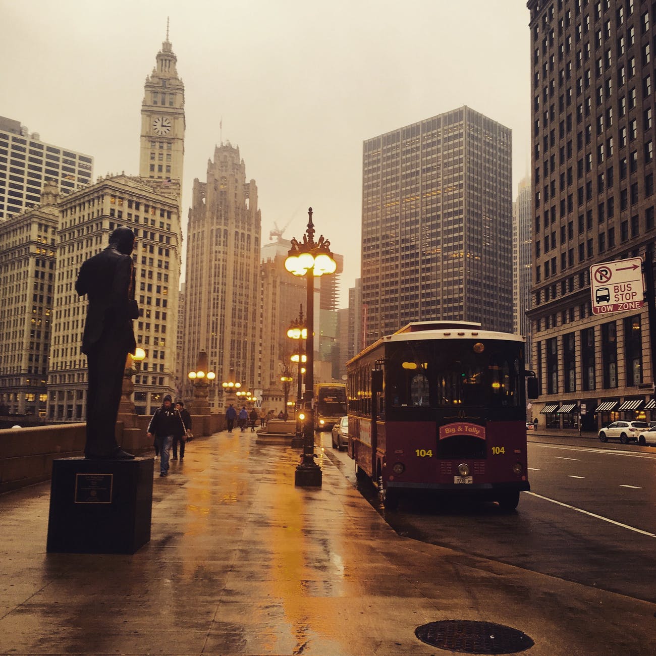
It is right to compare Chicago’s street network to something so obsessively exact. A recent academic study, “Urban spatial order: street network orientation, configuration, and entropy,” by Geoff Boeing, looked at the maps of 100 major world cities, and found that Chicago’s “exhibits the closest approximation of a single perfect grid.” Nowhere else have urban planners been so successful in imposing Euclidean order on natural surroundings. On a scale of 0 to 1, in which 1 is a perfect grid, Chicago scores 0.9. (The least-perfect grid is Charlotte, a Sunbelt city whose street system is more entropic than Rome or São Paulo.)
Why such a design?
The man hired to plat a town at the mouth of the Chicago River was James Thompson, a surveyor from Kaskaskia, and the father of the Chicago Grid. Illinois had already been divided into square townships and sections by the Northwest Ordinance of 1785. Since Thompson was subdividing a township section, he simply repeated that pattern in miniature when he designed Chicago’s first street map. It was less than half a square mile, bounded by Kinzie on the north, Washington on the south, Jefferson on the west and Dearborn on the east, but it was the template for a network that would eventually cover the 234 square miles of Chicago—and extend into suburbs beyond its borders…
Thompson’s grid was interrupted only by the river, and by established Native American trails which became diagonal streets: Elston, Clark, Milwaukee, Archer, Ogden. By 1869, the grid had become so integral to the city’s identity that the Tribune boasted, “There is no city where the opportunities for straight streets are so advantageous as in Chicago,” and demanded, “Give us straight, broad streets, running uninterruptedly from one extremity of the city to the other.”…
In our quest for orderliness, Chicago also has the advantage of being one of the flattest cities in the U.S., lying on a plain that was once the bottom of a proto-Great Lake. It would not be practical or possible to impose an uninterrupted grid on Pittsburgh or San Francisco, where streets wind sinuously around hills. As the study notes, “Boston features a grid in some neighborhoods like the Back Bay and South Boston, but they tend to not align with one another. Furthermore, the grids are not ubiquitous and Boston’s other streets wind in various directions, resulting from its age (old by American standards), terrain (relatively hilly), and historical annexation of various independent towns with their own pre-existing street networks.”
This sounds like a perfect storm of factors: a planner who applied methods from the Northwest Ordinance, a unique landscape that was flat and had only one waterway, and a quest for land development and profit with land that could be easily marked and developed.
Of course, this question of spatial order could be combined with consideration of how these different spatial orders are experienced. Do residents of Chicago and visitors have a better experience because of the grid or are cities, like Boston or San Francisco, with different spatial orders more interesting and vibrant? The grid has particular advantages for navigation but has less charm or uniqueness.
Come 1970, there was broad support for a portentous shift: Los Angeles would abandon the top-down planning that prevailed during a quarter century of postwar growth in favor of an ostensibly democratized approach. The city was divided into 35 community areas, each represented by a citizen advisory committee that would draw up a plan to guide its future. In theory, this would empower Angelenos from Brentwood to Boyle Heights to Watts.
In practice, it enabled what the Los Angeles land-use expert Greg Morrow calls “the homeowner revolution.” In his doctoral dissertation, he argued that a faction of wealthy, mostly white homeowners seized control of citizen advisory committees, especially on the Westside, to dominate land-use policy across the city. These homeowners contorted zoning rules in their neighborhoods to favor single-family houses, even though hardly more than a third of households in Los Angeles are owner-occupied, while nearly two-thirds are rented. By forming or joining nongovernmental homeowners’ associations that counted land-use rules as their biggest priority, these homeowners managed to wield disproportionate influence. Groups that favored more construction and lower rents, including Republicans in the L.A. Area Chamber of Commerce and Democrats in the Urban League, failed to grasp the stakes.
The Federation of Hillside and Canyon Associations, a coalition of about 50 homeowners’ groups, was one of the most powerful anti-growth forces in California, Morrow’s research showed. It began innocently in the 1950s, when residents living below newly developed hillsides sought stricter rules to prevent landslides. Morrow found little explicit evidence that these groups were motivated by racism, but even if all the members of this coalition had been willing to welcome neighbors of color in ensuing decades, their vehement opposition to the construction of denser housing and apartments served to keep their neighborhoods largely segregated. Many in the coalition had an earnestly held, quasi-romantic belief that a low-density city of single-family homes was the most wholesome, elevating environment and agreed that their preferred way of life was under threat. Conservatives worried that the government would destroy their neighborhoods with public-housing projects. Anti-capitalists railed against profit-driven developers. Environmentalists warned that only zero population growth would stave off mass starvation.
Much like the Reaganites who believed that “starving the beast” with tax cuts would shrink government, the anti-growth coalition embraced the theory that preventing the construction of housing would induce locals to have fewer kids and keep others from moving in. The initial wave of community plans, around 1970, “dramatically rolled back density,” Morrow wrote, “from a planned population of 10 million people down to roughly 4.1 million.” Overnight, the city of Los Angeles planned for a future with 6 million fewer residents. When Angelenos kept having children and outsiders kept moving into the city anyway, the housing deficit exploded and rents began their stratospheric rise.
Economists believe agglomeration — like the clustering of tech in the Bay Area — has historically been the result of two main forces. The first is what they call “human capital spillovers” — a fancy way of saying that people get smarter and more creative when they’re around other smart and creative people. Think informal conversations, or “serendipitous interactions,” over coffee in the break room or beers at the bar. These interactions, the theory says, are crucial to generating great ideas, and they encourage the incubation and development of brainiac clusters. The other force is the power of “matching” opportunities. When lots of tech firms, workers and investors clustered in Silicon Valley, there were lots more opportunities for productive marriages between them. As a result, companies that wanted to recruit, grow or get acquired often gravitated to places like the Bay Area.
However, remote work could actually improve certain matching possibilities. Companies can hire smart people anywhere in the world when they drop the requirement that they physically be in a central office. Not only that, they can pay them less. Moreover, killing the office can significantly lower costs for companies, which no longer have to pay for expensive real estate.
So, in this theory, the future of work and the economic geography of America really hinges on whether companies can create those “human capital spillovers” through computer screens or in offices in cheaper locations.
This is a phenomenon with a pretty broad reach as cities could be viewed as clusters of firms and organizations. What has been interesting to me in this field in recent years is how places like this come to develop and what it means for the character of the place.
Take Silicon Valley as an example. This is the home of the tech industry and, as the article notes, the big firms have committed to physically being there with large headquarters (including Google, Apple, and Facebook). These headquarters and office parks are themselves interesting and often a post-World War Two phenomena as highways and suburbanization brought many companies out of downtowns to more sprawling campuses. At the same time, the impact of all of this on the communities nearby is also important. What happens when the interests of the big tech company and the community collide (see a recent example of a Facebook mixed-use proposal)? What did these communities used to be like and what are they?
This is bigger than just the idea of employees working from home. This potential shift away from clustering would affect places themselves and how they are experienced. If thousands of workers are no longer in Silicon Valley, what does this do to those communities and the communities in which more workers are now at home? Silicon Valley became something unique with this tech activity but it could be a very different kind of place in several decades if there is new activity and new residents.
The same could be said for many other communities. What is New York City if Wall Street and the finance industry clusters elsewhere or disperses across the globe? What happens to Los Angeles if Hollywood disperses? And so on. The character of places depends in part on these clusters, their size, and their history. If the agglomerations shift, so will the character of communities.
That is why these three forgotten old News stories about Deep Ellum are so important. Almost unintentionally, they document what was really lost when I-345 was built. Sure, the neighborhood lost shops, hotels, and historic buildings. But the most significant loss was something more intangible. Call it memory, or character, or spirit. Call it a continuity of shared experience, or sense of identity shaped by the ebbs and flows of prosperity and decline.
Whatever you call it, that intangible quality is the real ingredient that makes cities and neighborhoods great. You can’t plan it or build it. You can’t fund it through philanthropy or market it in a tourism brochure. It isn’t “walkability” or “urbanism.” It takes generations to take shape. If you’re lucky, you capture it by carefully preserving all the beautifully ugly conditions that feed it life.
But if you lose it, it’s gone forever.
This helps explain the anger and protests in the last sixty years or so about highways bulldozing their way through urban neighborhoods. The particular form of highways – wide, noisy, made to help people speed through the community rather than visit or stop – and consequences – often bisecting lively places, erecting a barrier, destroying important structures, and furthering connections for wealthier and suburban residents at the expense of others – could be very detrimental.
More broadly, this hints at the delicate nature of neighborhood or community character. Change will happen but it matters how quickly the change happens, what form it takes, and who drives the process. Highways do not do well in these three metrics: they tend to go from bulldozing to construction to use within a few years, it is difficult to rebuild street life around it, and it is pushed on a community by others. Could highways support neighborhood character in any form? Perhaps not. But, it is a question asked not just of highways: the issue of character comes up with structures and development of a different form including denser housing among single-family homes, a major height differential such as a 20 story tall building in a community with a current max of five story buildings, or a new kind of land use. It could be easy to write off the concerns of local residents and leaders as NIMBY concerns but they may have a point in that new construction could change the character.
And, as noted above, the character of a place is vitally important. The people who live and work there have a particular understanding of what it is. When it is threatened by something as characterless as a highway, this can be particularly painful.
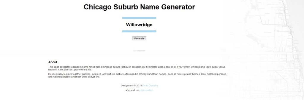
One-hundred years ago we named places very differently, Callary says. Places were named after a town founder, or family member, or after something that indicated the place’s actual, physical presence in the world. Today, it’s more common to name a place after what you want it to be, rather than what’s actually there.
So how exactly did developers and local leaders come up with all of the existing Chicago area names? It could have looked like this:
I had to check on Willowridge because it puts together two commonly used words in suburban place names. I found some companies with this name as well as one suburban street but no official place.
Here are the next ten names generated:
Romeowoods
Franklinsville
Elmburn
Hillhurst
Musmukda
Glenside
Rolling Bluff
Hillwoods
Highfield
Crystalfield
Out of these, I would vote for Glenside as the most probable.
On one hand, this all makes sense: suburbs often want to invoke nature and idyllic settings. On the other hand, such anodyne names invoke the conformity and dullness of suburbs many suburban critiques have noted.
What Curran either didn’t know, or wanted to erase, was the fact that up until the late 1890s, cities like “New-York” and “New-Jersey” were usually hyphenated to be consistent with other phrases that had both a noun and an adjective. In 1804, when the “New-York Historical Society” was founded, therefore, hyphenation was de rigueur. The practice of hyphenating New York was adhered to in books and newspapers, and adopted by other states. Even the New York Times featured a masthead written as The New–York Times until the late 1890s.
It was only when the pejorative phrasing of “hyphenated Americans” came into vogue in the 1890s, emboldened by Roosevelt’s anti-hyphen speech, that the pressure for the hyphen’s erasure came to pass.
Writing in 1924, several years after Roosevelt’s speech, Curran accused New York society of being overly judgmental, noting that “it is Ellis Island that catches the devil whenever a decision comes along that does not suit somebody. Of course, we are now in the midst of the open season for attacks on Ellis Island. We have usurped the place of the sea serpent and hay fever. We are ready to be roasted.” For the next twelve years he served as commissioner of immigration, Curran became more staunchly anti-immigrant, and his hatred was fueled by the anti–hyphenated Americanism espoused by people like Roosevelt and, later, Woodrow Wilson.
Curran was outraged that his beloved city would appear hyphenated, and he continually insisted that Morris call a meeting to pass a law that barred the use of a hyphen in New York. Meanwhile, curators, historians, and librarians banded together with antidiscrimination and immigrants’ rights defenders to defend a hyphenated New-York. Curran could not win this time, they insisted. The curators and librarians at the Historical Society bravely stood by the hyphen in their name, confirming that they had been founded in 1804, that the hyphen was in the original configuration of New-York, and that, no, this hyphen would not be erased. Hyphenated Americans and activists throughout New York City worried that this erasure would signal that they would not be welcome in the one city that was supposed to be a bastion of openness in America…
In the end, much to his chagrin, Curran lost this contest. No law was ever passed outlawing the hyphen, and it remains to this day, etched in stone on the building of the New-York Historical Society, a homage to the journey of the city and the hyphenated individuals who fought the good fight to keep the hyphen—and its many meanings—alive.
While it might be easy to dismiss this as a language debate from long ago, this excerpt highlights how language is not just about grammar or particular words: all of it is tied to how people see and understand the world. It sounds like the hyphen in place names followed conventions for the day of separating adjectives and nouns that went together. As hyphens later helped demarcate identity, they generated controversy.
Would New York be a different place today if it were New-York? Perhaps it might work like this. The hyphen implies a more hybrid identity than the solid “New York” together. Would this point people back to the original roots of the city, not as an American place but a British territory and before that a Dutch city? All of this could help put together contradictory ideas including American individualism and capitalism, colonialism, slavery, and pluralism. Add to that the immigrant history of New York from a variety of countries at numerous time points and perhaps the hyphenated version would help highlight the bricolage that is the city of five boroughs, numerous neighborhoods, and uncountable different experiences. “New-York” is still being shaped, “New York” already exists.
The idea of the global city and metropolis of today as a city state is not a new one. However, I was interested to see this discussion of how Los Angeles might really fit the bill:
Los Angeles fits the city-state frame well, certainly better than it does a lot of other possibilities—if we update the model a bit. In 2010, Forbessuggested that if the criteria for a place to be considered a city-state were modernized for the 21st century, certain global capitals might qualify thanks to a few key features: a big port to sustain trade; investors from overseas; money laundering; international museums worth visiting; multiple languages spoken in good restaurants serving alcohol; and an ambition to host the World Cup…
The city-state label rings true to me for hazier reasons as well. Los Angeles lacks the bedrock Americana that anchor towns like Chicago, New York, and Boston. In terms of identity, it doesn’t attach to the state of California the way that Houston and Dallas serve Texas. As for international ties, Miami has Latin America, Seattle has Canada and Asia, but Los Angeles, perhaps the city of globalism, has everybody. We’re Angelenos first, Californians second, Americans third or not at all.
“I absolutely think of Los Angeles as a city-state,” Mayor Eric Garcetti told me a few months ago. “The root of politics is the same as the root word in Greek for “city”: polis. People engage in politics because they came to a city and vice versa.” I wanted to point out that lots of citizens don’t engage with Greater L.A. in the way he described. If anything, civic life here often feels optional. Residents stay in the bounds of their neighborhood. Voters supported a $1.2 billion bond in 2016 to build supportive housing, but progress on the homeless problem is abysmal, stymied in part by NIMBYism. To borrow Garcetti’s measure, had life in the Greek city-states been as complacent, as mean, as L.A. often feels? “The man who took no interest in the affairs of state was not a man who minded his own business,” the ancient historian Thucydides wrote, “but a man who had no business being in Athens at all.”
My unspoken question for Garcetti was a nod to the fact that the city-state label can stretch only so far, at least until Los Angeles secedes from the United States. Angelenos may not always feel particularly American, but L.A. continues to receive policies and funding from Sacramento, which receives the nod—or not—from Washington. Our tap water flows from the Colorado River. A fifth of our power is from a coal plant in Utah. Los Angeles simply isn’t self-reliant. We have plenty of investment from abroad, but no local currency. The world’s largest jail system, but no independent military. Garcetti recently proposed a guaranteed-basic-income program that would be the country’s largest experiment of its kind—but that’s only even theoretically possible thanks to funding from President Joe Biden’s $1.9 trillion American Rescue Plan.
The main argument here seems to be that Los Angeles has the infrastructure, amenities, and identity needed to be a city state. On the other hand, the political fragmentation and reliance on other parts of the American federal system may be obstacles. However, I am not sure
Political fragmentation comes through the sprawling and decentralized landscape. Who is in change? Whose opinions should hold sway? Going further, what is the relationship between the sprawling city and the sprawling suburbs? This would seem to be in tension with the identity as Angelenos. On which issues does the identity bring political unity and where do the fault lines emerge when fragmentation bests identity?
A city state could make relationships with other entities. But, this might be a little different than having steady relationships within a system versus having to negotiate new relationships if Los Angeles became a city state. Take an example relevant to sprawling LA: could a city state of Los Angeles afford to fund all of the highways that right way get monies from the federal government? Or, would this then courage a LA city state to pursue more mass transit? Right now, the highways might be an amenity but
If the mayor of Los Angeles operates now as if his city is a city state, what exactly does this mean? Is there an American city that is already more city state like and provides a model of how this might look in the future?
Mount Hoy offers views of Chicago thirty miles to the east.
For real: Highland Park, Park Ridge, Arlington Heights, Mount Prospect, Prospect Heights, Palos Heights, Chicago Heights, Ford Heights, Barrington Hills, Palos Hills, Rolling Meadows.
And before you say: “But wait! There is some elevation out in the ‘burbs!” Let’s make something clear: You’re not wrong. Chicago’s Loop is at about 570 feet above sea level, and the high point of Cook County is near Barrington Hills at 950 feet. That height difference is just under 400 feet, and that’s spread over 40 miles. If we were talking about any other state in the country (besides Florida) you’d barely notice the difference. In other words, in Illinois, the default standards are low for what’s considered high…
Chicago suburbs end up with names that imply elevation in these two ways: crowd-sourced rebranding and straight-up marketing…
One-hundred years ago we named places very differently, Callary says. Places were named after a town founder, or family member, or after something that indicated the place’s actual, physical presence in the world. Today, it’s more common to name a place after what you want it to be, rather than what’s actually there.
Real estate development is a powerful driver. How could developers and communities differentiate themselves from the hundreds of other suburbs in the Chicago region? Pick an idyllic name and hopefully the moniker plus the new development brings in people and businesses. The image of a mountain or hill would be an attractive one; they are both pleasant to look at and offer vistas from the top.
While none of the communities near me are named after a higher elevation, this story did remind me of the highest height around (see the picture above): a small hill made out of a landfill. Because the area is so flat, on a clear day you can see the tallest buildings in downtown Chicago thirty miles to the east. All this from an artificial 150 foot hill:
Starting in 1965 trash collection agencies and community members were invited to drop off junk and other discarded garbage items. At the end of each day county workers spread the clay, which they had excavated, onto the growing pile of garbage named Mount Hoy after the pioneering family.
Mount Hoy quickly earned its nickname of Mount Trashmore. As the Chicago Tribune article in 1973 announcing the competition of the project read, the hope was to create a popular ski destination by literally “turning garbage to ski slopes.” Although the idea seems a bit farfetched, the City of Evanston was undertaking a similar project and many were trying to convince the City of Chicago to do the same thing.
Overall three millions cubic yards of garbage and clay went into Mount Hoy, becoming a 150 foot hill. By 1974 Mount Trashmore was supposed to host four ski slopes, a snow machine and a chair lift along with two toboggan slides, however a less elaborate setup welcomed skiers and tubers to the area.
Ignore the venting for the gasses in the landfill and it is almost like a real hill…if we know what those are in northeastern Illinois.