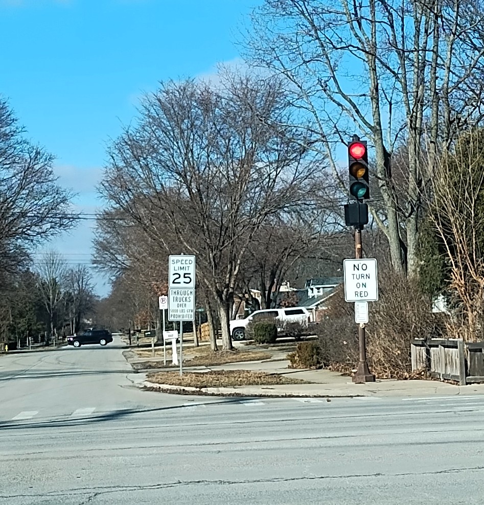
Accounting for the “iron law of congestion”

Why is building more lanes to address traffic issues not the best way to go? See the iron law of congestion:

Photo by Pixabay on Pexels.com

There’s a name for the principle behind that apparent paradox: induced demand. Economist Anthony Downs is often credited with first articulating this “iron law of congestion” in 1962, as construction crews were hacking interstates through American cities. Downs published a seminal paper with a stark warning: “On urban commuter expressways, peak-hour traffic congestion rises to meet maximum capacity.” In other words, adding lanes won’t cure snarled traffic; the additional car space inevitably invites more trips, until gridlock is as bad as ever.

Downs was not the first to sound an alarm about the futility of expanding urban roadways — not by a long shot. In 1932, an association representing streetcars warned that “as fast as improvements are made in existing arteries of travel … they are saturated by an increasing volume of traffic.” In 1955, urban observer Lewis Mumford wrote a series of essays in the New Yorker titled “The Roaring Traffic’s Boom,” in which he memorably compared a highway planner widening a congested highway to “the tailor’s remedy for obesity — letting out the seams of trousers and loosening the belt. [T]his does nothing to curb the greedy appetites that have caused the fat to accumulate.”

Downs’ iron law applies not only to U.S. cities, which have grown more traffic-jammed despite billions of dollars in fresh pavement, but also to those around the world. Highway expansions in Norway and Britain haven’t reduced congestion there, either. The principle now meets little opposition among economists and urban planners. “It’s widely accepted,” says John Caskey, who teaches induced demand as part of his urban economics course at Swarthmore College. “For economists interested in urban transportation, there isn’t really any debate.”…

But turning down a new highway lane remains politically challenging. “The highway construction system has vast momentum,” says Rose, the historian. “It has the authority of highway contractors, builders and labor unions. Here is something that labor and management really can agree on: a highway contract.” The auto industry, too, continues to benefit from ongoing investments that expand the “floor space” allotted to its products. In 2019, Tesla CEO Elon Musk tweeted that induced demand “is one of the most irrational theories I’ve ever heard.”

Build it and they will come.

As I read through the longer narrative in this article, it seems that the needs of the automobile were prioritized by drivers, businesses, those in the road industry, and politicians. This has been going on for roughly a century; would academic theories with evidence behind them be able to overcome these interests?

Perhaps at some point in the future, we will able to look back at “peak road” or “peak highway.” Is there a point where new roads and highways or lanes are no longer pursued in the United States? Even if population growth stagnated or slowed, would the United States continue to build roadways? Maybe the costs of maintaining all those roadways will help lead to this moment. It is hard to imagine other scenarios; even as fewer people drive to work compared to earlier years, traffic continues.

The disadvantages and advantages to living on a major suburban road

I regularly drive by a single-family home that is located on a busy four lane road. Decades ago, this was a two lane road and traffic was lighter. Now, it is a road with a 50 MPH speed limit and many cars zooming daily between suburbs. In the morning, the school bus stops on the busy road to pick up kids from one house. Most of the housing in this area is located on streets that branch off this main road; this is common in suburban areas as residential neighborhood traffic is routed to arterial roads.

Photo by Caio on Pexels.com

When looking for housing years ago, I remember seeing homes located on such roads. What might be the advantages and disadvantages of such properties?

Advantages:

-Quick access to a major road. Suburban subdivisions can be big and the roads winding. It can take minutes just to leave the neighborhood.

-A reduced price. If the road is busy and noisy, this may mean the property is cheaper than comparable houses and lots.

-A location along a known road.

Disadvantages:

-Noise. The sound of cars and trucks is constant.

-Safety. Many suburbanites might wonder whether kids can safely play.

-Lower property values in comparison to similar properties.

-Less parking. If you have lots of people over, is the driveway big enough for everyone?

I would guess many suburbanites would choose not to live on or even near such a major road if they can help it. At the same time, plenty of suburbs have houses located along busy and fast roads.

Turning a busy road into a “smart corridor”

The Illinois Department of Transportation has plans to create two new “smart corridors” along major suburban roads:

Photo by Kaique Rocha on Pexels.com

The improvements include: traffic signal upgrades to modernize the corridors, synchronizing signals, dynamic message signs in strategic spots, and accommodations for pedestrians, officials said.

The Route 64 revamp stretches between Smith/Kautz Road and Route 50 (Cicero Avenue); the Route 56 redo runs from Route 59 to York Street.

For walkers and transit users, upgrades to sidewalks, crosswalks and pedestrian signals are coming, plus new, strategically located bus stops that expedite traffic flow.

“The long-range idea is to get those corridors working as efficiently as possible and to help support transit and buses,” IDOT District 1 Program Development Engineer John Baszek said.

These are busy roads – tens of thousands of vehicles each day – with high rates of speed. The project seems to have two goals: (1) improve traffic flow and (2) facilitate use beyond cars and trucks. Can both be done at the same time?

Not only have I driven these roads, I have biked along both roads. There is a lot that would have to be done to make this feel like a safe and pleasant experience for bicyclists and pedestrians. Having more cars flowing more efficiently does not seem like it necessarily fits with this.

As a driver, synchronized lights seem to make a lot of sense. On some of the regular routes I drive, I am pretty sure the lights are intentionally not in my favor; i.e., I turn left at the green arrow from one major road to the next and am immediately met with a red light. Keeping traffic flowing would seem to be good for congestion and the environment (through avoiding idling and stopping and starting).

Putting together statistical data and experiences, Right Turn on Red edition

A discussion of Red Turn on Red (ROTR) pits statistical evidence and experiential data:

Photo by Jack Gittoes on Pexels.com

Critics of the D.C. bill have pointed out the lack of data showing the dangers of RTOR, but many people who don’t use cars know instinctively how dangerous turning vehicles can be. “Our current safety studies fail to capture the reality of the constant near misses and confrontations that result between these motorists and pedestrians, which can be observed daily just by observing a typical busy intersection with RTOR,” Schultheiss says.

When teaching a research methods class, I can often come back to this observation about how sociologists approach data and evidence: we want both “facts” and “interpretations” to get the complete story of what is going on. In this particular situation, here is what that might mean: even if the statistical data suggests ROTR is not very dangerous, it matters that people still fear cars turning right on red. The experiences of pedestrians, bicyclists, and others on sidewalks and streets is part of the larger picture of understanding turning right on red. This would go alongside the data and experiences of vehicles and drivers.

Once this full set of data is collected, making policy decisions is another matter. If leaders want to prioritize vehicles, that is one choice. Or, as the piece suggests, some cities want to rethink streets and transportation, and they can end ROTR. But, it would be advisable to have all of the evidence before acting.

The limited safety of pedestrians and bicyclists even in quiet residential neighborhoods

Street and intersections in quiet suburban subdivisions are not necessarily designed with the safety of pedestrians and bicyclists in mind:

Photo by Jeswin Thomas on Pexels.com

The station reached out to county officials and the local police precinct; everyone sure scratched their heads about that one. There was supposed to be a stop sign there, said the county, and they didn’t know why there wasn’t one installed. The police made sure to point out that it wasn’t their fault, either, because, they said, residents hadn’t complained. “Some residents have now reached out to us requesting additional signage,” said the precinct’s commissioner, James Mett. “In the coming days, we plan to examine and research the issue to determine the best course of action moving forward.” A few phone calls later, it was announced that a new stop sign would be installed Thursday.

So, that’s one thing that made this street unsafe. But there are plenty of other problems, not unique to this intersection but common to many, many American streets, that also made it unsafe. There’s no signage of any kind to alert drivers to the possibility that walkers or cyclists might want to cross. There are no traffic-calming design elements, like speed bumps, raised crosswalks (or any kind of crosswalk), or extended curbs. There’s no protected bike lane.

The speed limit on this road is 30 miles per hour, as it is on roads in all Texas cities. Last year a Texas lawmaker introduced a bill to lower the speed limit on such roads to 25 miles per hour. Cars traveling 30 miles per hour are 43 percent more likely to kill pedestrians they hit than cars traveling 25 miles per hour, according to the AAA Foundation for Traffic Safety. This is the lawmaker’s third attempt to pass this bill, and it seems to have been just as successful as the first two times, as nothing has happened to the bill in more than a year. (We don’t know how fast the driver of the Hyundai was traveling. Maybe she was going less than 30 miles per hour. Or maybe she was going faster; after all, Google Street View suggests you can drive the entire length of Kings Mill Road, a circuit of nearly a mile, and never see a single speed limit sign.)

And notably, the driver who struck and killed Chase Delarios was driving a midsize SUV. The heavier the car, the more likely it is to kill a person if it strikes them. At between 3,500 and 5,000 pounds (depending on specific model), a 2017 Hyundai Santa Fe is more than a match for an 8-year-old and his bike. (The post-crash local news coverage shows the bike, horribly, jammed under the Hyundai’s rear wheel.)

And the conclusion:

Like most American streets, Kings Mill Road is not a safe area for pedestrians or people riding bikes. It’s designed for drivers, and drivers use it that way. That’s the system we’re trapped in…

In the United States, cars and vehicles with engines rule the roads. We have built whole systems and ways of life to accommodate them and ease their travel. It is supported by public and private money, public sentiment, and an ongoing series of decisions.

If you are traveling via other means, you have to be aware and careful. Know where vehicles are at all times. Be cautious in crossing, even at clearly marked walkways. Be ready to move quickly if needed. Make yourself visible to vehicles.

To change this or seriously address this would require a long-term effort to redesign basic aspects of everyday American life. It can be done, but a sustained series of actions is difficult to organize and execute.

I missed the urban scooter revolution

On a recent trip to Los Angeles, I saw a part of urban life I primarily read about: the proliferation of electric scooters.

The scooters were all over the place. There were more scooter users in the bike lanes than bicycles. Scooters of multiple services zoomed by. They could be parked anywhere.

They make a lot of sense in a place with good weather, limited mass transit, and a good number of visitors. (On the other hand, they do not make as much sense right next to the large vehicles Americans often drive.)

One additional thought: are these scooters doing what the Segway was supposed to do or could have done?

A freight train through the center of town

At-grade railroad crossings present dangers. But, what if the freight line runs right down the middle of a road through the center of town? This is LaGrange, Kentucky:

More images here and here.

This is an unusual situation but it hints at the intertwining of trains and communities. This would be a strong reminder of the goods moving across the landscape and how it intersects with traffic, pedestrians, buildings, and residents. Many might prefer that freight just shows up where it needs to – usually at the point of use or access by consumers – but it has to come from and to somewhere first.

Now I wonder how many American communities have this particular situation. This might be more common in big cities or in cities in other countries where mass transit lines run on roadways. Or, this could encourage remembrances of the extensive streetcar systems in many American communities that utilized local roadways.

Many goods come via truck, few want to encounter those trucks on a suburban road

Trucking is essential to the American economy. However, it is not desirable to encounter many trucks on local roads. Here is how one Chicago area county wants to address the issue:

Photo by Craig Adderley on Pexels.com

“The key is really getting trucks onto the interstate as safely and efficiently as possible,” said Patricia Mangano, senior transportation planner with the Chicago Metropolitan Agency for Planning.

As the county grows and the region continues to be an important national transportation hub, the study recommends strategies to minimize the negative impact of freight traffic to residents and the environment…

The report says that high volumes of truck traffic have led to safety and congestion concerns, especially in sensitive areas such as historic districts, neighborhoods or environmentally protected areas. The study notes western Will County’s natural and cultural assets, such as Midewin National Tallgrass Prairie, Abraham Lincoln National Cemetery and the Kankakee River, could be negatively affected by new development and traffic…

“We are the proverbial crossroads of America,” he said, noting residents just want to ensure they can get from work to home to their children’s activities without being caught in traffic.

In recent decades, Will County has become home to an increasing number of warehouses and intermodal facilities. This could be viewed as a positive for economic activity and growth which then leads to more tax revenues, jobs, and prestige.

Yet, certain industries do not necessarily mesh well with the suburban single-family home ideal. Trucks are related to a number of concerns residents have about all sorts of land uses: noise, traffic, lights, threats to the residential ideal they hope for.

I see the point of routing truck traffic along particular roads. This also has the effect of altering those roads. I can think of several major thoroughfares near here that are full of truck traffic during the day. Driving on these roads can be quite different than driving on other main roads. And because the way many suburban communities are laid out, there are often not good alternative routes since traffic in general is funneled from smaller residential streets to larger volume roads.

An impractical suggestion that might please suburban residents: have truck only roads that lead from industrial and commercial properties straight to highways. In many locations, this might work as warehouses and distribution centers are clustered together as are big box stores and shopping malls. On suburban roads without big trucks, suburbanites might occasionally find the opportunity to drive like people do in car commercials: on the open road.

The ongoing tactic of social movements blocking roads

I saw news earlier this week about efforts by climate activists in Germany to draw attention to their cause:

Photo by Life Matters on Pexels.com

Climate activists on Wednesday blocked roads leading to Germany’s three biggest airports, gluing themselves to the ground before police arrived.

Members of the group Uprising of the Last Generation said they wanted to disrupt cargo and passenger traffic at the airports in Frankfurt, Munich and Berlin.

The group has demanded that the government take measures to end food waste. It argues that throwing away vast amounts of usable food contributes to hunger and climate change.

Past protests involving the blocking of roads and ports have drawn criticism from officials across the political spectrum.

The last sentence in the portion above is telling. This particular technique draws criticism from all sides because it effectively complicates one of the most important assumptions of Western life: drivers should be able to get where they want with minimal disruption.

It may be one thing to have a crowd or protest so large that it takes over streets and roadways. It is another matter to more deliberately block main arteries and highways. Residents depend on these, truckers depend on these, emergency vehicles depend on these. Whether it is Black Lives Matters protestors or truckers in Ottawa, Canada or climate change activists, interrupting the normal flow of people and goods “works.”

I put “works” in quotes because it is less clear that this tactic leads to significant change. It may draw attention and disrupt daily life. If it angers many of the people who might align with the movement, is this helpful? Is media attention the primary focus? If governments find ways to clear roadways – and many communities have guidelines about applying for permits to hold parades/rallies/protests and this includes where these can take place – is this a win in the end?

I would not expect this tactic to go away soon.

Complicated urban repairs: 20 years to repair 11 blocks of Park Ave above and below ground

Manhattan is dense, above ground and below ground. Hence, the city is planning for a 20 year project to to a portion of Park Avenue:

Photo by Vlad Cheu021ban on Pexels.com

The good news is the city finally has plans to restore 11 blocks of Park Avenue north of Grand Central to a semblance of its former glory, Bloomberg reports, expanding the median from a useless 20 feet to a potentially-rejuvenating 48 feet. That redesigned street could include bike paths, walking paths, and generally more space for things other than cars or pretty things for people in cars to look at as they drive by.

The bad news is many if not most of the people currently living and working in New York will not be around to enjoy it once it’s done. It will take 20 years to redesign these 11 blocks, according to the city’s Department of Transportation. Yes, you read that right. The project to redesign 11 blocks of a Manhattan street will not be completed until 2042.

But there is no mistake, according to both DOT and Kaye Dyja, Powers’s spokesperson. As Dyja explained, “The reason the construction is going to take a long time is because they’re improving the underground railroads leading to Grand Central, as well as redoing the ‘train sheds.’ This entails that they’re digging up the ground, so the construction will have to take place in stages which will end up taking many years to complete.”

The project Dyja is referring to is a massive $2 billion renovation of the Metro North infrastructure underneath Park Avenue from Grand Central to 57th Street. Park Avenue is a bridge over those tracks, and like many of the U.S.’s bridges, this one is falling apart, too. The project will involve ripping up sidewalks and the median of Park Avenue a couple blocks at a time, going section by section, down the stretch of Park Avenue. It is expected to cause more or less permanent disruption to the Midtown East area, to varying degrees, over the next two decades. 

As a kid, I remember reading books with cross-sections of underground Manhattan. Seeing all of that infrastructure needed for modern urban life – pilings for skyscrapers, subways, water pipes and sewers, etc. – was fascinating.

The flip side of that is the work it takes to make significant changes to such a system. It takes time (and money) to work around what is there and complete the work.

The time is one factor but I wonder about how the budgets will work over a 20 year period. Large American infrastructure projects can have a tendency to stretch in terms of time and budget as the work is underway.

I would love to say I will check in on this in twenty years but that is a long commitment…