While Smith’s actions came from a protective place, his efforts may be fruitless, as there’s little evidence to support the effectiveness of advisory signs in regard to changing driver behavior or making children safer. In fact, the National Cooperative Highway Research Program firmly discourages the use of signs that read “Caution — children at play” or “Slow — Children.” One reason, points out Slate, is common sense. “If the driver does not notice the characteristics of a neighborhood as they drive down the street, why would they notice a sign as they pass it, or remember it for more than a few seconds once they have passed it?” an engineer from an online forum noted on the website.
There’s also the possibility that a sign emphasizing the presence of children in one location may imply that an absence of warning would mean no kids are present in another. And finally, such warnings could falsely convey that the street is a play area. The same principle applies to neighborhood stop signs, which encourage drivers to actually speed up in between them.
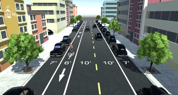
One proposed solution:
“It largely comes down to awareness,” Janette Fennell, founder and president of KidsAndCars, a nonprofit safety organization, tells Yahoo Parenting. “Drivers often have an ‘It can’t happen to me’ mindset when speeding, and most people overestimate their driving skills.” But lowering the speed limit even a little helps reduce the number of accidents and increase the survival rate of victims, according to research published by the AAA Foundation for Traffic Safety. “I’d estimate that a person is about 74 percent more likely to be killed if they’re struck by vehicles traveling at 30 mph than at 25 mph,” study co-author Brian Tefft told Wired.
Here is a better solution as even speed limits can only do so much: more road diets. In many places, streets are far too wide for what is needed for typical traffic. This gives drivers the impression that they have a margin of error. And, having nothing in their path – ranging from speed bumps to stop signs to parked cars – only contributes to driving faster. If you really want people to slow down when driving through residential neighborhoods, we should: (1) narrow streets, (2) have regular street parking, and (3) plant trees closer to the roadway. All of these things would give drivers more consistent indicators that they can’t drive as fast. Drivers may not like this as it feels more closed in and they have to pay attention more (will someone open a car door? How far do I get over if a car is coming from the opposite direction?) but it will slow them down.
Making these changes would take a major effort as many streets have been built extra-wide for decades. Yet, we have often privileged the car when designing roads and one of the consequences is faster driving and increased risk for pedestrians and others utilizing roadways.
A more radical solution that wouldn’t require changing many roads? Promoting driverless cars that closely control how fast vehicles move.